|
Oko Skakavice
Voda iz prokletijskog vrela Oko Skakavice (alb. Syni Skakavcit), prosječne temperature do 5°C, izbija na oko 1000 mnv iz stijene u gotovo kružnoj uvali promjera 30-ak metara. |
PODZEMNI VODOTOCI
|
Ponornica (slov. ponikalnica; eng. subterranean river; lok. ponikvica) je poseban tip vodotoka u krškim terenima; to je tekućica koja se gubi u ponorima terena građenog od propusnih stijena i dijelom svoje dužine ili cijelom dužinom teče ispod zemlje špiljskim kanalima kroz krški sustav.
Ponornice su tipična pojava u kršu Dinarida, gdje čine većinu tokova svježe vode. Površinski se u dinarskom području često javljaju kao snažna vrela, a poniru i po nekoliko puta prije ušća, na razini mora ili pak, kao vrulje, ispod razine mora. Ponornice su osobito važne za hidrologiju krša, budući isti vodeni tok u kontinuitetu spaja više zemljopisno razdvojenih područja. Time ponornice hidrološki povezuju naizgled zemljopisno odvojena područja u jedinstveno porječje. Izgradnjom hidroelektrana tokovi su većih ponornica u Hrvatskoj, Bosni i Hercegovini i Crnoj Gori promijenjeni, a neke od tih rijeka samo za najvišega vodostaja dospijevaju do svojih ponora. Pojedini oblik ponornica mogu biti i rezultat pokrivanja rijeke i/ili preusmjeravanje njenog toka u odvodne kanale, obično u sklopu urbanog razvoja. Suprotni proces je poznat kao odanjivanje (srp.) i predstavlja vidljiv oblik rječne restauracije. IZVOR Ponornica. Hrvatska enciklopedija, mrežno izdanje. Leksikografski zavod Miroslav Krleža, 2013. – 2024. Pristupljeno 31.5.2024. Najpoznatije rijeke ponornice Slovenija Hrvatska
Bosna i Hercegovina
Crna Gora
Srbija
|

Ponornički tokovi u Lici
Izvor: Hrvatska enciklopedija 
Rijeka Reka teče podzemno kroz Šumeču jamu u Škocjanskim jamama
|
Ponornice u Sloveniji
Reka

Tlocrt Škocjanskih jama
Izvor: Javni zavod Park Škocjanske jame 2015. |

|
Šumeča jama


|

Cerkvenikov most priječi rijeku Reku 45 metara (prosjek) iznad njezina toka.

|
Ponornice u (dinarskoj) Italiji
Ponornice u Hrvatskoj
|
Najveće rijeke ponornice u Hrvatskoj su rijeke Lika i Gacka. Izgradnjom hidroenergetskoga sustava HE Senj u njihovu su porječju stvorena su baražna jezera.
Ostale rijeke ponornice u Hrvatskoj su: Vrljika, Jaruga, Krbava, Ombla, Pazinčica, Dobra i Drežnica. |
Ponornice u Bosni i Hercegovini
|
Najpoznatije ponornice u Bosni i Hercegovini su rijeka Trebišnjica, koja protječe kroz Trebinje i istočnu Hercegovinu, i Trebižat, koji protječe kroz zapadnu Hercegovinu.
Ostale ponornice. Glamočkim poljem teku rijeke Ribnjak i Jaruga. Njihove vode poniru na obodu Glamočkog polja te se ponovo javljaju u Livanjskom polju. Ondje teku Jaruga, Sturba i Plovuća. Najveći dio ovih voda završava u Buškom jezeru. Kupreškim poljem teče rijeka Milača, a kao Šuica se javlja u Duvanjskom polju. Ona nestaje u ponorima na obodu Duvanjskog polja te dijelom otječe u Buško jezero, a drugim dijelom se ponovo javlja na vrelima ispod Zalima kao Ričina. Ričina nestaje u Prološkom blatu. Njene se vode javljaju u Vrliki i Matici koje teku kroz Imotsko polje (dijelom u Hrvatskoj). Ove vode se zatim javljaju na vrelu rijeke Tihaljine koja zatim teče kroz Ljubuško polje kao rijeka Mlade. Na kraju se kao rijeka Trebižat ulijeva u Neretvu. Kroz Nevesinjsko polje protječe Zalomska rijeka (Zalomka), čije vode nakon poniranja, podzemno teku u pravcu vrela rijeke Bune i Bregave, pritoka Neretve. Dabarsko polje ima svoju ponornicu, rijeku Opačicu. Trebišnjica. Rijeka Trebišnjica je najduža rijeka ponornica u BiH, a jedna je od najdužih i na svijetu. Sliv Trebišnjice leži u području koje prima najveću količinu kiše u toku godine, a ovo je ujedno i najkrševitija oblast u Bosni i Hercegovini. Duga je 96,5 km, a izvorište se nalazi na padinama Lebršnika i Čemerna. Polja u kršu kroz koja protječe Trebišnjica kaskadno su poredana od 950 do 220 m n.v. S Lebršnika u Gatačko polje dotječe Mušnica, a sa Čemerna Gračanica koja se u Gatačkom polju ulijeva u Mušnicu. Mušnica se u Cerničkom polju javlja kao Ključka rijeka. Ova rijeka ponire i nakon podzemnog toka ponovo se javlja u izvorima i vrelima Fatničkog polja kao Fatnička rijeka. Ona se zatim, nakon 30 km podzemnog toka, javlja u obliku snažnih vrela kod Bileće kao rijeka Trebišnjica. Trebišnjica protječe kroz Trebinjsko i Popovo polje, u kojem se gubi kroz ponore. Vode ove rijeke razilaze se prema donjoj Neretvi, odnosno u pravcu Hutovog blata, zatim prema Slanom u Hrvatskoj gdje se ulijeva u obliku vrulja u Jadransko more, a sjeverozapadno od Dubrovnika izbija iz pećine Gruž treći krak Trebišnjice kao rijeka Ombla. Rijeka Trebišnjica je sustavom betonskih čepova i betoniranjem korita pretvorena u stalan površinski tok, a njena voda se koristi za pokretanje turbina hidrocentrala Svitava-Čapljina, Grančarevo i Plat. Danas je u fazi realizacije projekt pod nazivom Gornji horizonti kojim se planira gradnja energetskih objekata, umjetnih akumulacija i sustava tunela kojim bi se podzemne vode, koje iz istočne Hercegovine otječu prema Neretvi i Jadranskom moru, preusmjerile ka rijeci Trebišnjici. Smatra se da će ovim projektom biti ugrožena vrela rijeka Bune, Bunice i Bregave. IZVOR Globus - Udruženje nastavnika i profesora geografije Kantona Sarajevo's albums |
Ponornice u Crnoj Gori
|
Rijeka Komarnica izvire u Dobrom dolu i u toj svojoj prvoj etapi je ponornica. Na površini se ponovo pojavljuje u dolini, koja je po njoj i dobila ime
|
Ponornice u Srbiji
|
Najveći broj ponornica u Srbiji ne javlja se u dinarskim već u Karpatsko-balkanskim planinama, gdje postoji 70 većih ovakvih tokova. Ponornica u dinarskom području Srbije ima najviše na području Valjevskog krasa i na Pešteri.
IZVOR Ponornice u Srbiji. Wikipedija (sr) |
Područje Valjevskog krasa
|
Valjevski kras obihvaća površinu od 280 km². U hidrografskom smislu tu postoje dve cjeline: Lelićko - bačevački kras s hidrografskim sustavom Sušica - Jablanica (pritok Kolubare) - Gradac i Lepenički kras sa sustavom Ribnica - Lepenica. I jedan i drugi su suhi i bezvodni s velikim brojem ponornica. Među njima najveće su: Polička reka, Povlenska reka, Pocibrava, Plandište, Kopljarnica, Radmilovac i dr. Polička i Povlenska reka su izvorišni kraci Sušice. Njihove vode gube se pri prelazu toka na vapnenačku podlogu, kao i u koritu Sušice, a pojavljuju se na vrelima Paklja i Zelenci s lijeve strane Graca. Plandište je najveća i vodom najbogatija ponornica u slivu Lepenice. Vode joj nastaju u 7 ponora koji se često začepljuju nanosom, tako da se ispred njih stvaraju mala jezera. Podzemno teče kroz najdužu pećinu Valjevskog kraja i izbija na Ključkim vrelima i nekim manjim izvorima.
|
Područje Pešteri
|
U zaleđu pećine iz koje izbija vrelo rijeke Raške nalazi se Koštam - polje. Kroz njega teku dvije ponornice. Delimeđa se gubi nakon 8 km površinskog toka u ponoru dubokom 9 m. Nizvodno od istoimenog vrela, Likobska reka nakon 6 km ponire kod Ograđe. Obe protječu koje kroz vapnenačku pregradu (srp. kračnjačka prečaga) ispod brda Golača i pojavljuju se na vrelu Raške. Prvi ponor udaljen je od vrela 4,5, a drugi 2,2 kilometra.
Apsolutno najveća ponornica u Srbiji je Boroštica u Pešterskom polju, čija se voda nakon 12,5 km podzemnog toka pojavljuje u klisuri Bistrice na 680 m nadmorske visine. Boroštica nastaje od Đerekarskog vrela koje izbija na južnom obodu Pešterske kotline. Ovaj naziv dobila je od sela Boroštice na ulazu Peštersko polje, a do tada teče kao Đerekarska reka. Do glavnog ponora pod Sukom, na 1.150 metara u središnjem dijelu polja, površinski teče 18 km, rječno korito je veoma izvijugano i duboko do 1 metar. Boroštica prima veći broj potoka među kojima je najveća Kamenjača dugačka 4 km. |
Ponornice u Albaniji
PODZEMNA JEZERA
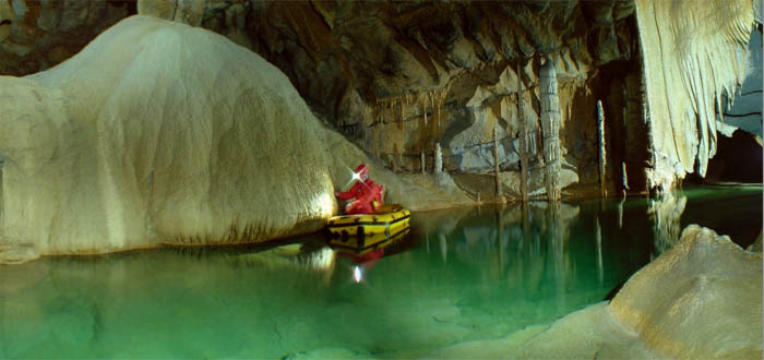
Križna jama - Beneški pristan
Izvor fotografije: Javno vlasništvo, Wikipedija 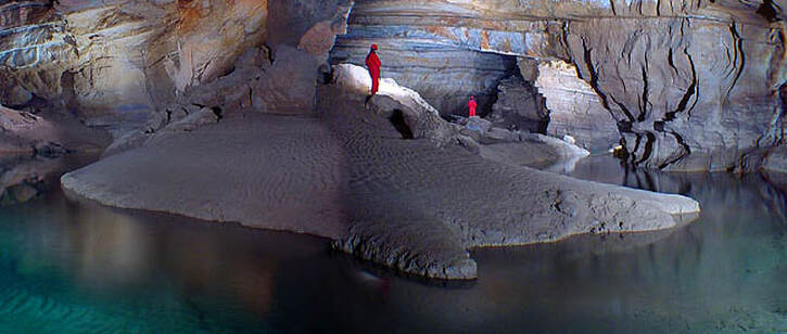
Podzemni otok u Križnoj jami - Beneški pristan
Izvor fotografije: Javno vlasništvo, Wikipedija |
Najbrojnija i najpoznatija otkrivena podzemna jezera u Sloveniji su ona u Križnoj jami. Križna jama leži u trokutu između Loškog polja, Cerkniškog polja i Bloške visoravni. Među krškim špiljama Križna jama je u svijetu poznata upravo po podzemnim jezerima. U Jezerskom (Jezerski rov) i Pisanom rovu (Pisani rov) ima ih 22, a zajedno s tunelom Blata više od 40. Jezera su nastala iza barijera koje su izgradile sige, do čijeg je stvaranja došlo kalcita iz vode. Izuzetno spori rast ovih pregrada (do 0,1 mm godišnje) i njihova krhkost glavna su prepreka masovnom turizmu u špilji i ograničavanju dnevnog turističkog posjeta vodenom dijelu špilje na 4 osobe.
|
PONORI
Ponor je otvor ili sustav pukotina u propusnim stijenama u kojima se površinska tekućica gubi, ponire. Ovisno o naravi tekućica, postoje trajni i periodični ponori. Posebno su zanimljivi ponori u našem kršu što naizmjence, za niskih voda, gutaju vodu, a za visokih, kao snažna vrela, izbacuju vodu; takvi se ponori u Lici nazivaju rigala. Naš izraz ponor sve se više upotrebljava i u međunarodnoj literaturi.
IZVOR Ponor. Hrvatska enciklopedija, mrežno izdanje. Leksikografski zavod Miroslav Krleža, 2013. – 2024. Pristupljeno 31.5.2024.
IZVOR Ponor. Hrvatska enciklopedija, mrežno izdanje. Leksikografski zavod Miroslav Krleža, 2013. – 2024. Pristupljeno 31.5.2024.
KRŠKA VRELA
Definicije
1. krški izvor; vrelo: Izvor koji izbija iz karstificiranog vapnenca.
Vrbanac, 2013.
2. vrelo: općenito raširen narodni naziv za izbijanja vode iz krškog podzemlja; iz pukotina voda izbija, "vrije" naglo i u velikim količinama, za razliku od izvora koji se procjeđuju kroz propusne stijene. krška su specifičnost vrela, iz kojih u kišnom razdoblju istječe golema količina vode, te odjednom nastaje moćna tekućica, a u sušno doba presahnu; prema vrelu kod mjesta Vaucluse (Francuska) taj tip je nazvan "vokliško vrelo", a sve češće se upotrebljava širi termin krško vrelo, jer je taj način izbijanja u skladu s podzemnim protjecanjem kroz pukotine, koje se vrši brzo i s velikim kolebanjima. prema vremenskom toku istjecanja vrela se dijele na trajna, periodska i povremena. Povremeno ili "intermitentno" (v.) vrelo je specifična pojava, koja je od različitih dimenzija podzemnih šupljina i složenog protjecanja. s obzirom na prirodu pukotinskog protjecanja pod hidrostatskim tlakom vrela mogu biti sifonska ili uzlazna i prelivna, a po izgledu bunarasta, pukotinska, pećinska, spiljska i sl. U skladu s tlačnim pukotinskim protjecanjem su i podmorska vrela vrulje (v.).
Roglić, 1973.
3. izvor: Mjesto izviranja krške vode iz akvifera.
Vrbanac, 2013.
|
Izvori u kršu ili krški izvori su izvori vode koji su dio sustava krša. U taj sustav su uključene i podzemna odvodnja područja.
Krški izvori su obično dio speleološkog sustava na kojem ponornica stiže na površinu zemlje. Tako je često moguće ući na izvoru u sustav špilje i istražiti ga. Glavna karakteristika krških izvora proizlazi iz činjenice da voda brzo prolazi kroz špilje. Zato je efekt čišćenja vode u podzemlju minimalan. Voda izvire već nakon nekoliko dana ponovo na izvoru. Oluje, otopljeni snijeg i sezonske promjene u oborinama se na količini vode koja izvire uglavnom jasno odražava. Na mnogim krškim izvorima u suho godišnje doba količina vode koja izvire varira. Karakteristike krških izvora naseljenim područjima općenito nisu u pogodni za korištenje za pitku vodu. Neravnomjerna količina vode te veliki udio kamenca u vodi može dovesti do loše kvalitete vode. Kraško vrelo je vrelo u krasu. Predstavlja mjesto istjecanja vodotoka, koji je prethodno već formiran u podzemlju kretanjem voda kroz kraške kanale. Kraška vrela odlikuju se pojavom velike količine vode na mjestu izviranja, odnosno istjecanjem gotovo rijeke na površinu terena. Izvorište je, po pravilu, amfiteatralno udubljenje strmih, pa čak i vertikalnih strana, otvoreno s jedne strane. Voda istječe iz pećine, koja je najčešće formirana duž veće rupture, čija se trasa obično može prepoznati na stranama izvorišta.
Brojni su primjeri kraških vrela: izvorište Mlave kod Žagubice, vrelo Trebišnjice kod Bileće (koje je sada potopljeno vještačkom akumulacijom HE Grančarevo), Pivsko oko, potopljeno akumulacijom HE Piva, vrelo Bosne kod Sarajeva. Kraško vrelo. Wikipedija (bs)(hr) 
Naslovna fotografija
Krško vrelo rijeke Slunjčice (Slušnice), pritoke rijeke Korane. Vrelo Slunjčice je u obliku malog jezerca koje se nalazi 5 km južno od Slunja na 240 m nadmorske visine. Slunjčica je tipična krška rijeka, a predstavlja završetak podzemnog toka rijeke Jesenice. |

Vrelo Cetine kod sela Cetina (Civljane)

Vrelo Cetine kod sela Cetina (Civljane)
Inače, izvori uz obale Jadranskog mora često su zaslanjeni, budući da se duboko u krškom podzemlju može miješati slatka i morska voda.
Diver Explore Stunning Cetina River Cave (Underwater Exploration)
Autor: Caters Clips Datum objave: 26.10.2021. Opis. An underwater photographer has shared a series of impressive images of the Cetina river spring taken during a 70-meter cave dive. Martin Strmiska, 40, from Slovakia, snapped these beautiful images of the crystal blue Centina river spring in Croatia earlier this summer. These stunning images showcase the picture-perfect surroundings and what can be found within the depths of this spring. The underwater photographer said: "The reality of the view down into the gorge is even more incredible than any image every captured on the internet. *Please contact [email protected] for media / licensing / broadcast usage* SUBMIT A VIDEO: https://www.catersnews.com/submit-con... Connect with Caters: Twitter: / caters_news Facebook: / caterstv Website: https://www.catersnews.com Instagram: / caters_news |
Vrulje
vrulje, podmorski izvori u kojima izbija slatka voda iz podzemlja susjednoga kopna; nalaze se u blizini istočne jadranske obale i otoka. Nastaju pod utjecajem hidrostatskoga tlaka u podzemnim krškim kanalima, koji završavaju ispod morskoga dna. Iskorištavaju se i za opskrbu stanovništva pitkom vodom u obalnom pojasu na kopnu i na otocima. Najpoznatije su vrulje u zaljevu Velike vrulje (krajnji sjeverozapadni dio Makarskoga primorja).
IZVOR Vrulje. Hrvatska enciklopedija, mrežno izdanje. Leksikografski zavod Miroslav Krleža, 2013. – 2024. Pristupljeno 31.5.2024.
IZVOR Vrulje. Hrvatska enciklopedija, mrežno izdanje. Leksikografski zavod Miroslav Krleža, 2013. – 2024. Pristupljeno 31.5.2024.
IZVORI I LITERATURA
BAUČIĆ, Ivo: Hydrological characteristics of the Dinaric karst in Croatia with a special regards to the underground water connections. Naše jame, 1965. vol.7, br.1-2, str. 61-72, Ljubljana. (PDF)PDF)
- Sažetak. HIDROLOŠKE OSOBITOSTI DINARSKOG KRŠA U HRVATSKOJ S POSEBNIM OSVRTOM NA PODZEMNE VODNE VEZE. Nakon drugog svjetskog rata u Dinarskom kršu vrše se opsežni hidrotehnički zahvati. Energetskom i ostalom korišćenju voda u kršu nužno prethode raznovrsna istraživanja. Za upoznavanje osobina krške hidrologije osobito značenje imaju brojna bojenja ponora, kojima su utvrđene njihove podzemne veze s vrelima. Do sada je u hrvatskom dijelu Dinarskog krša bojenjem utvrđivana veza na 39 ponora. Time je obuhvaćen relativno mali deo svih ponora u ovom dijelu Dinarida, ali su unatoč tome postignuti značajni rezultati. Egzaktnim podacima omogućeno je bolje sagledavanje karakteristika podzemnog kretanja vode i eksperimentalna metoda postaje osnov upoznavanja hidrologije krša. Na priloženim skicama (slike 1—4) uneseni su osnovni rezultati dosadašnjih bojenja. Ponovljeno bojenje nekih ponora redovito je dalo drugačije rezultate podzemnih vodnih veza, pa do sada utvrđene veze ponor—izvor ne treba smatrati isključivima, već rezultatom specifičnih hidroloških uvjeta u vrijeme kada je izvršeno bojenje. Uzevši u cjelini dosadašnja bojenja ukazuju na vrlo velike raznolikosti podzemnog kretanja vode u pojedinim područjima obzirom na specifične petrografske, geološke, tektonske, orografske, klimatske i ostale uvjete. Utvrđeni su vrlo raznoliki međusobni odnosi podzemnih tokova. U podzemlju se tokovi račvaju, spajaju, ukrštajavu na različitim nivoima i slično. Unutrašnjošću krša tokovi se kreću različitom brzinom, obojena voda pojavljuje se na vrelima u vrlo raznolikim koncentracijama boje i drugo. Sve ove i mnoge druge osobitosti podzemnih vodnih veza u Dinarskom kršu upućuju na vrlo veliku složenost hidrologije krša, onemogućuju šabloniziranje procesa podzemne cirkulacije vode i iziskuju svestrana i višestruka istraživanja svakog krš-kog toka u različitim hidrološkim uvjetima.
- Sažetak. This paper gives a comprehensive explanation of the hydrogeological and hydrological characteristics of different water occurrence, which exists in the extremely complex Dinaric karst system. The area and boundaries of the Dinaric karst have never been precisely determined. It covers about 60,000 km2 stretching the length of the eastern coast of the Adriatic Sea, from the Bay of Trieste in the north, to the Drim River basin in the south, and the Western Morava River valley in the east. Due to very high infiltration rates, overland and surface flows are rare in comparison with non-karst terrains. The Dinaric karst is an extremely heterogeneous medium which can be explained only by the use of a great number of measurements points and by continuously monitoring and measuring different parameters. The hydrogeological and hydrological regime of all water phenomena in the Dinaric karst depends mostly upon the interaction between groundwater and surface water. The dominant flow of the groundwater contained in the Dinaric karst is towards the Adriatic Sea through rivers and many permanent and intermittent coastal and submarine springs. The paper presents many examples of karst water phenomena from the Dinaric karst: (1) springs (Jadro, Ombla and Crnojevića Springs); (2) open streamflows (Ljubljanica, Pazinčica, Dobra, Lika, Gacka, Krka, Zrmanja and Cetina Rivers); (3) lakes and wetlands (Cerknica, Vrana, Plitvice, Vransko, Red and Blue Lakes); and (4) coastal and island karst (Brač Island).
- Sažetak. The very complex system of sinking, losing and underground transboundary Karst rivers, lakes and aquifers in the central part of the deep and bare Dinaric karst in Croatia and Bosnia and Herzegovina is analysed. The groundwater and surface water are hydraulically connected through numerous karst forms which facilitate the exchange of water between the surface and subsurface. A complex underground conduit system is an inherent characteristic karst system analysed. Groundwater and surface water exchange with both adjacent and distant aquifers through underground routes or inflows from surface streams and artificial reservoirs. Because of a complex surface and underground karst features, which strongly influenced its hydrological and hydrogeological regime, the main open stream flow, with a longitude of about 106 km, undergoes eight name changes. In this paper, it is noted as “the eight-name river”. In fact, it represents one river with losing, sinking and underground stream sections. Different surface and underground karst forms play crucial roles in the way the water flowing over the surface and on the underground sections of its catchment. The analysed area is full of varied and often spectacular surface landforms, including for example the Blue and Red Lakes and the Kravice Waterfall. The analyses made in the paper show the existence of a decreasing trend of mean annual discharges on the eight-name river, which can cause numerous problems in the regional water resource management of this transboundary river and catchment.
- Sažetak. Researching the hydrogeological properties of karst systems is very challenging due to their extreme heterogeneity. A grey-box approach in karst research combines the results from classical hydrogeological methods with direct observations within the karstic underground, i.e. in the caves. Isotope research has become a widely used method in the investigation of karst systems. The results presented are of a preliminary 2H and 18O stable isotope study of the Northern Velebit karst system (Croatia) employing the grey-box approach. Groundwater samples were collected during two summer expeditions in deep caves within the karst massif. Monthly precipitation samples were also collected (at three locations between approx. 900 m and 1600 m altitude), as well as water samples at some of the most significant springs, i.e. discharge outlets of the system. For a single expedition, the stable isotope composition is almost constant, i.e. the stable isotope measurements are within the measurement error across the complete cave profile. Similar characteristics across different caves during the same year were also noted. Samples of water from the springs were taken during base-flow conditions and they have similar isotopic contents to the cave water. The results obtained indicate that homogenization of the water already occurs within the subsurface epikarst zone above the sampling locations in the caves, but a future extended sampling campaign during variable hydrologic conditions is needed to confirm this. The final research goal is to establish a conceptual grey-box model for the functioning of this complex hydrogeological system.
Osnovne karakteristike
Ponornice se javljaju kao stalni i periodični tokovi. Njihova voda nastaje (ako se radi o mjestu gdje tekućica ponire u zelmju onda ona također nestaje...za promatrača ..........) u udubljenjima koja se nazivaju ponor, propast i surdupina.
Neke ponornice nastaju u pećinama, kao što je slučaj sa Pivkom u Postojinskoj jami i Reke u Škocijanskoj jami.
Pivka (Piuca, tal.) je druga po veličini rijeka ponornica na julijskom Krasu (na jugozapadu Slovenije) duga 27 km, koja teče u Pivskoj i Postojnskoj kotlini, poznata kao graditelj Postojnske jame u koju ponire.
Geografske karakteristike[uredi | uredi kod]
Pivka u Postojnskoj jamiPivka izvire kod sela Zagorje u Općini Pivka ispod planine Gračišče (791 m n/v) na nadmorskoj visini od 555 metara[1] , ali glavni dotok vode dolaze iz nižih izvora u okolici Pivke te izvora ispod Tabora. Ostali pritoci Pivke su sa zapadnih padina Javornika i Snežnika. Glavnina vodotoka se formira od Zagorja do Matenje Vasi. Na svom toku Pivka je izdubila jezerca nazvana po obližnjim mjestima: Kalško jezero, Zagorsko jezero, Drskovško jezero i Parsko jezero. Pivka kroz Pivsku dolinu protiče kroz brojne okuke pa su na tom području česte poplave. Nakon 27 km toka po Pivskoj kotlini završava u Postojnskom kraškom polju gdje ispod brda Sovič ponire u Postojnsku jamu.
Njen podzemni tok u jami (5,2 km) najbolje se vidi u dvije spilje Črnoj i Pivki. Njen kasniji tok je tajna, nestaje u Planini, pretpostavlja se da najveći dio njenih voda završava u rijeci Rak pritoci Ljubljanice, a kod većih vodostaja izlijeva se u Reki-Timava i Vipavi.
Voda ponornica izbija u vidu jačih vrela u drugim dolinama, na morskoj obali pa čak i ispod morskih površina, obrazujući podmorske izvore — urulje. Najbolje su proučene veze između ponornica i vrela u Slovenačkom krasu, naročito u Notranjskoj, potom u slivu Cetine i sliva Trebišnice.
Doline ponornica se ne spajaju sa drugim dolinama; one su izolovane, zatvorene stenovitim prečugama, pa ih je narod zato nazvao „slepe doline”. Krečnjački tereni čine 9,5 procenata (8414 km2) ukupne površine Republike Srbije.
Osobine krasa
Kras je složena morfološko-hidrološka pojava, koja nepovoljno utiče na oticanja površinskih i podzemnih voda. Jedna od njegovih glavnih karakteristika je siromaštvo povšinskih tokova. Atmosferska voda veoma brzo ponire, tako da su retki vodotoci stalni na čitavoj svojoj dužini. Održali su se samo oni koji potiču iz vododržljivih terena i tokovi nastali od jačih kraških vrela. Veliki broj površinskih vodotoka u krasu su povremeni i imaju vrlo izrazita kolebanja vodostaja i proticaja — od suvog rečnog korita do visokih poplavnih voda. Nasuprot površinskom, u krečnjacima preovlađuje podzemno oticanje. Ta voda izbija u vidu snažnih vrela, kao što su vrela Mlave, Belog Drima, Raške, Crnog Timoka, Moravicevce, Crnice itd.
Ponor
Ponori se najčešće nalaze po obodu kraških polja i duž rečnih dolina. Mogu da budu u obliku jama i pećina, širokih ili sasvim uskih pukotina. Od toga zavisi i njihov kapacitet gutanja vode, što oscilira u zavisnosti od godišnjeg doba, tj. od priticanja vode. Kod jednih je taj kapacitet samo nekoliko desetina litara u sekundi, a kod drugih više kubnih metara u sekundi. Jedna ista reka može više puta da ponire i da se javi na površini. Dešava se da vode jedne ponornice podzemno oteknu ispod razvođa u sliv druge reke. Ima slučajeva da se dve ili više ponornica spoje podzemno ili površinski u jednu veću reku. Sve ovo ukazuje na obrazovanje vodotoka u krasu vrlo složeno.
https://sr.wikipedia.org/sr-el/%D0%9F%D0%BE%D0%BD%D0%BE%D1%80%D0%BD%D0%B8%D1%86%D0%B0
https://sl.wikipedia.org/wiki/Ponikalnica