|
|
DO YOU HAVE PLANS TO VISIT DINARIC ALPS AREA?
HUGE CHOICE OF ACCOMMODATION AT: 
|
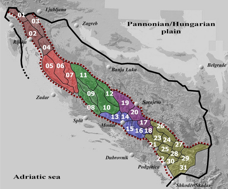
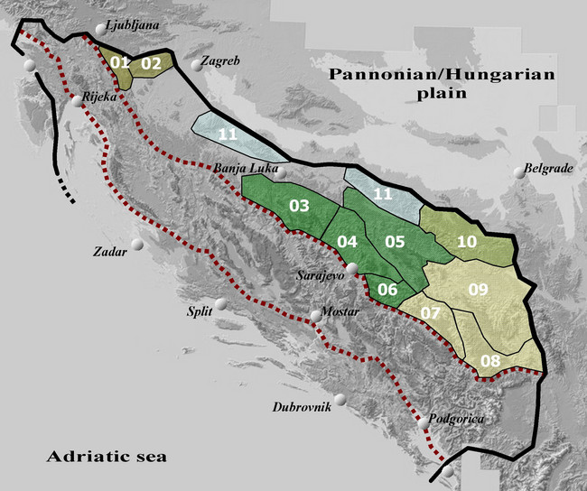
The Maritime Belt of the Dinaric Alps runs in NW-SE direction between the Central Dinaric Belt (High Dinaric Alps) and the Adriatic Sea, parallel to both.
The groups and mountains of this Belt belong to four different geographical areas: Mountains of the Northern Adriatic,Mountains of Dalmatia, Mountains of Montenegrin Deep Karst (in fact Maritime and Central Montenegro) and Mountains of Lower Herzegovina - all stretching from Italy and Slovenia, through Croatia, Montenegro, Herzegovina (part of the state of Bosnia and Herzegovina), until they finally reach Albania - in a small section of Rumija mountain, NW of the city of Shkoder/Skadar.
The groups and mountains of this Belt belong to four different geographical areas: Mountains of the Northern Adriatic,Mountains of Dalmatia, Mountains of Montenegrin Deep Karst (in fact Maritime and Central Montenegro) and Mountains of Lower Herzegovina - all stretching from Italy and Slovenia, through Croatia, Montenegro, Herzegovina (part of the state of Bosnia and Herzegovina), until they finally reach Albania - in a small section of Rumija mountain, NW of the city of Shkoder/Skadar.
Area Overview
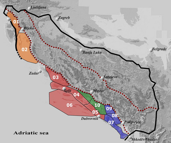
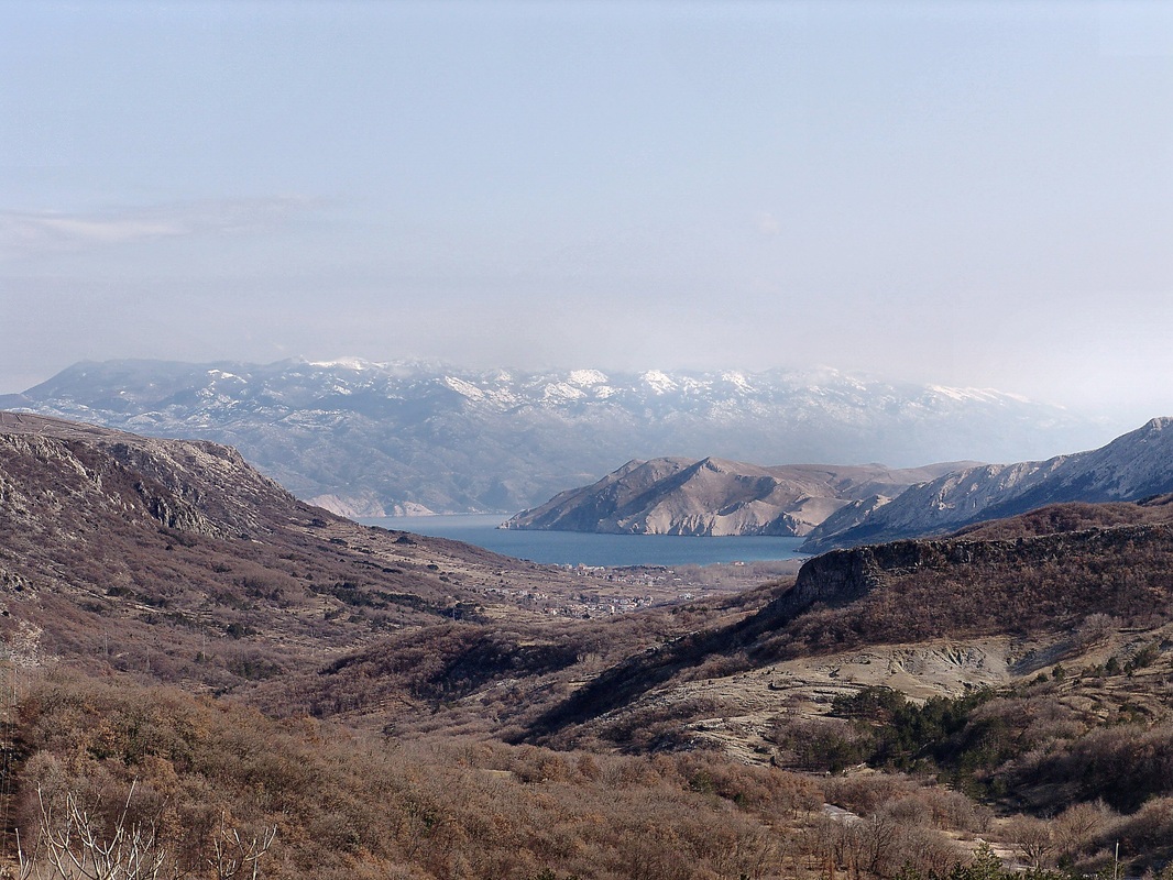
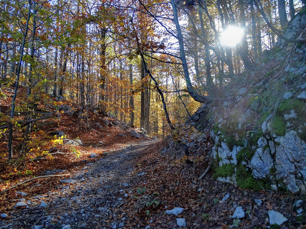
This Area consists of two groups: Mountains of Istria and Kras (Group A-01) and the Islands of the Northern Adriatic (Group A-02). This is typical limestone area with mountains, heights and islands´ tops stretching in NW-SE direction. Because of a submerged section of Maritime Belt in northern Dalmatia this Area is separated from other southern groups in the Maritime Dinaric Belt by the sea and lower laying land areas of northern Dalmatia.
This Area consists of two groups: Mountains of Istria and Kras (Group A-01) and the Islands of the Northern Adriatic (Group A-02). This is typical limestone area with mountains, heights and islands´ tops stretching in NW-SE direction. Because of a submerged section of Maritime Belt in northern Dalmatia this Area is separated from other southern groups in the Maritime Dinaric Belt by the sea and lower laying land areas of northern Dalmatia.
| Group A-01. Mountains of Istria and Kras Countries: Italy, Slovenia, Croatia |
|
This group consists of two distinctive parts: a karstic plateau Kras/Carso and more mountainous area situated in northern part of Istria peninsula. Although relatively small, this group is shared by even three states: Italy, Slovenia and Croatia.
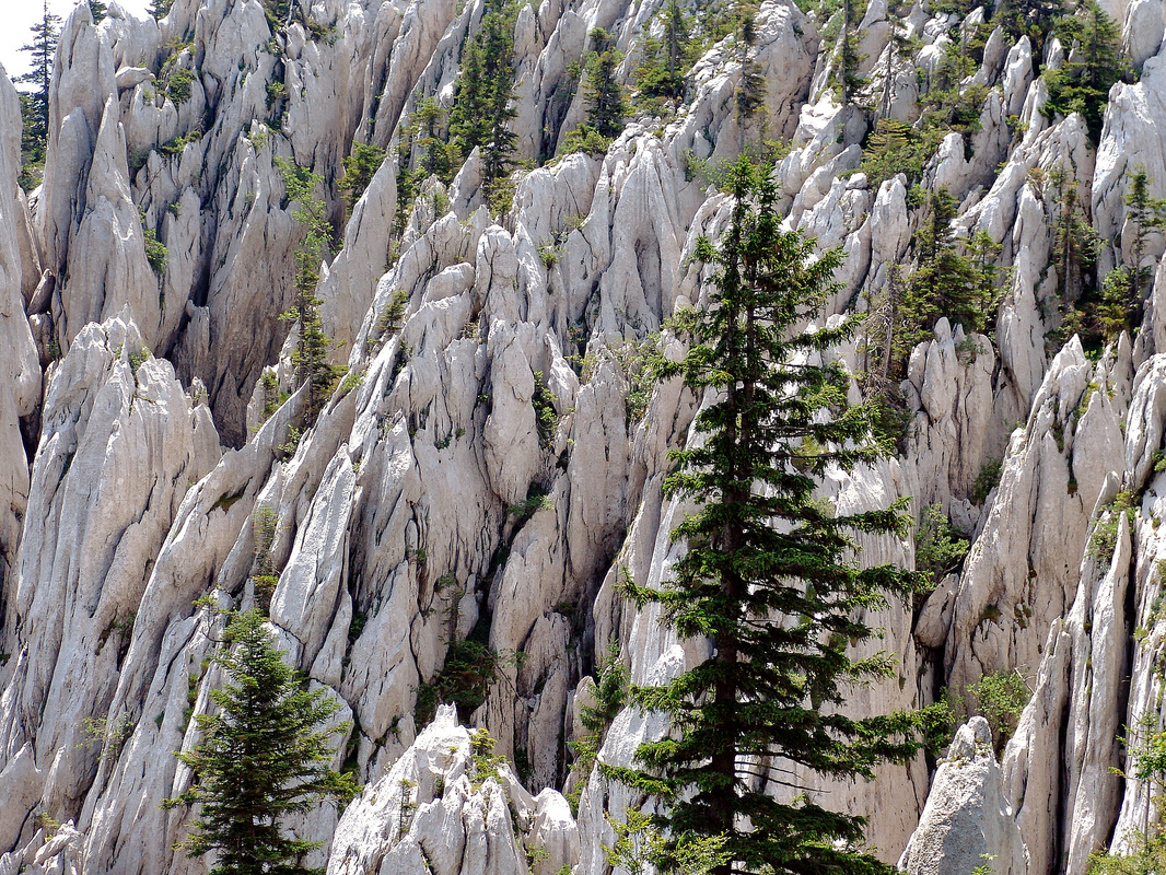
Kras (Carso, Italian) is the northernmost part of the Maritime Dinaric Chain. It is completely karstic and predominantly plateau-like region situated among Vipava valley, Goriška hills (Goriška brda) and the Bay of Triest, with the highest mountain Vremščica (1,025 m). To the European public and scientists Kras was the nearest region with developed karstic features, and the pioneering karst research started just here. Therefore, a scientific term for such terrain - a Karst - is a derivation from German word (Karst) for Kras/Carso. Further to SE, in northern Istria peninsula the terrain rises up forming limestone mountain of Ćićarija and reaches its highest point in Učka mountain (1,396 m), above the Bay of Kvarner (Kvarnerski zaljev, orig.). 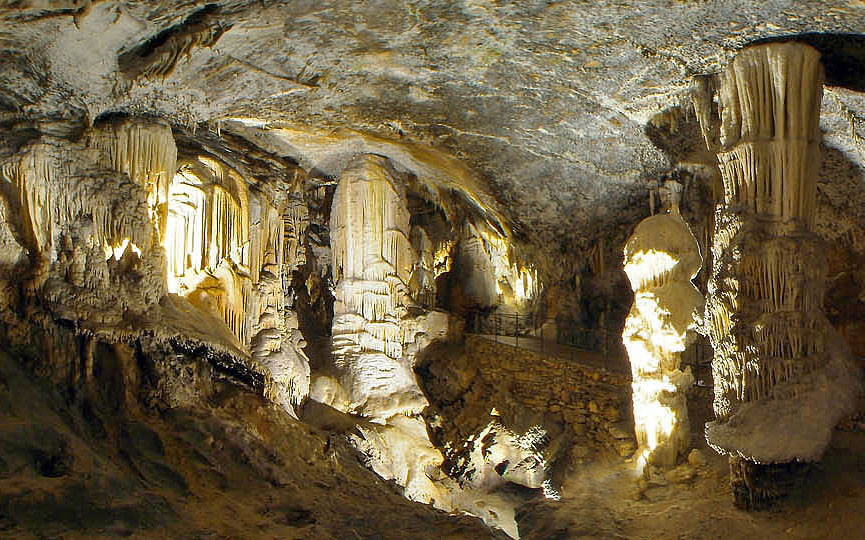
Postojna cave (Postojnska jama)
Soutce: Wikipedija; Author: Boštjan Burger |
|


| Group A-02. Islands of the Northern Adriatic Country: Croatia |
|
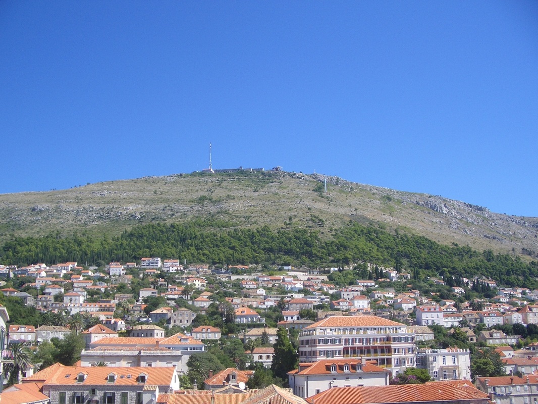
Although it consists of more islands (many of them with steep rocky shores) this group is the continuation of Mountains of Istria and Kras, and a part of Dinaric Maritime Belt that was submerged by the sea in geological history. The group is situated in northern Adriatic (Eastern Coast of the Adriatic) in the area usually called Kvarner (after the Bay of Kvarner), south of the port of Rijeka and stretches along the mainland further in SE direction until it reaches parts of Northern Dalmatia region (island of Pag, f.e.). What were previously Dinaric mountain peaks, now are many islands with summits which also attract many people to climb them, especially because of spectacular views from them and a year-round climbing season.

The island of Rab
Northern barren and rocky side of the island of Rab (the long ridge behind). The southern side of this island, protected from bura (bora) winds from Velebit massif is very green and fertile! In front (on the right side, in front of Rab) is a rocky Goli otok ("Barren island"). |
|

Area Overview
Still Following main Dinaric geological, tectonic and orographic (morphological) direction, after forming the islands of the Northern Adriatic, the Maritime Belt continues in northern Dalmatia (a region in Croatia), again as a part of the mainland, but at a lower altitude, without higher mountains. This area, east of the town of Zadar is called Ravni kotari (Plain counties, transl.).
Further to SE, still in Dalmatia, more mountain groups rise, some of them forming distinctive mountain ranges. The northernmost of these ranges, shared both by Dalmatia in Croatia and the state of Bosnia and Herzegovina, is long Dinara massif which is in fact a part of High Dinaric Alps (Central Belt) and it is not considered as a part of the Maritime Belt. The other mountain ranges in Dalmatia are: Central Dalmatian Range (Group A-03), Dalmatian Maritime Range (Group A-04), Southern Dalmatian-Herzegovian Range (Group A-05) and the Islands of Central and Southern Adriatic (Group A-06).
| Group A-03. Central Dalmatian Range Country: Croatia |
|
This range has central position in Dalmatia, between the coastal mountains and Dinara massif in High Dinaric Alps, mostly situated inside a trapezoid made of towns and cites of Split, Sibenik, Knin and Sinj. Actually, this area is called Dalmatinska zagora (Dalmatian Hinterland). This is area with more solitaire mountains which run in classical Dnaric NW-SE direction
|
|
| Group A-04. Dalmatian Maritime Range Country: Croatia |
|
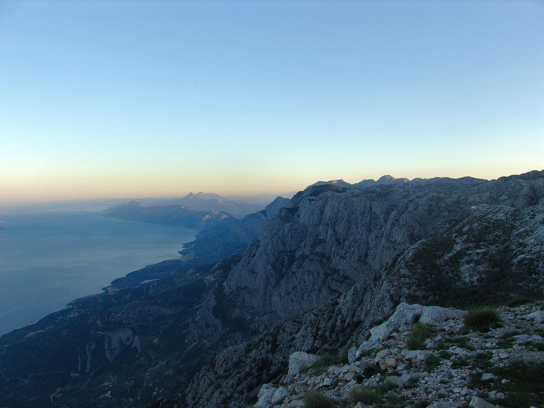
This group consists of middle-height elongated mountains rising above the Dalamtian coast from Krka river estuary to Neretva river delta. It reaches its highest point in the mountain of Biokovo (1,762 m). Both sides of this range are steep, especially the maritime one, which makes a huge wall above the coastal sea-resorts.

Biokovo
Morning view from the peak of Vošac (1,421m) on Biokovo mountain. This peak, with a small mountain hut on it, is situated at the maritime edge of high the high karstic Biokovo plateau, high above the Dalmatian coast (the town of Makarska). In the background, along the coast, stretches the lower mountain Omiška Dinara (Imber or Kula peak, 863 m), and further inland is high pyramidal-shape peak of Sveti Jure (1,319 m) on Mosor mountain. |
|
| Group A-05. Southern Dalmatia and Mediterranean Herzegovina Countries: Croatia, Bosnia and Herzegovina |
|
This is a SE continuation of Dalmatian maritime (and its hinterland) ranges, still a part of Dalmatian tectonic plate and also the first in a ranges of mountains that stretch further into Eastern Lower Herzegovina. This coastal range stretches from delta of Neretva river on its NW, to the tectonic fault that separates the group on its SE side, from the neighboring Orjen massif massif in Montenegrin Maritime Range. Along its NE edge lays long karstic field Popovo polje in Eastern Herzegovina, while on the other side the SW slopes of the range drop steep into the Adriatic sea, in the area known as Dubrovnik Riviera.
Although the most of this group is situated outside of what is contemporary Dalmatia proper, and although this range could also have been named f.e. Neretva-Dubrovnik Group, I have decided to name the group as a Southern Dalmatian one, because of morphological, tectonic and also historical factors which connects Dalmatia, Herzegovina and this Dubrovnik-Neretva area. 
Žaba mountain in Herzegovina region
|
|
| Group A-06. Islands of central and southern Adriatic Countries: Croatia, Bosnia and Herzegovina |
|
The mountain group consists of more islands´ heights and the summits of elongated Pelješac peninsula, which all stretch in the same direction and together follow a westward turn (so called Hvar direction) a drift from the classical NW-SE Dinaric direction. Like the Islands of the Northern Adriatic these summits are also former mountain ranges of Dinaric Alps system that were submerged by the sea.

St. Elias (Sveti Ilija) is the highest peak Pelješac peninsula
|
|
Area overview
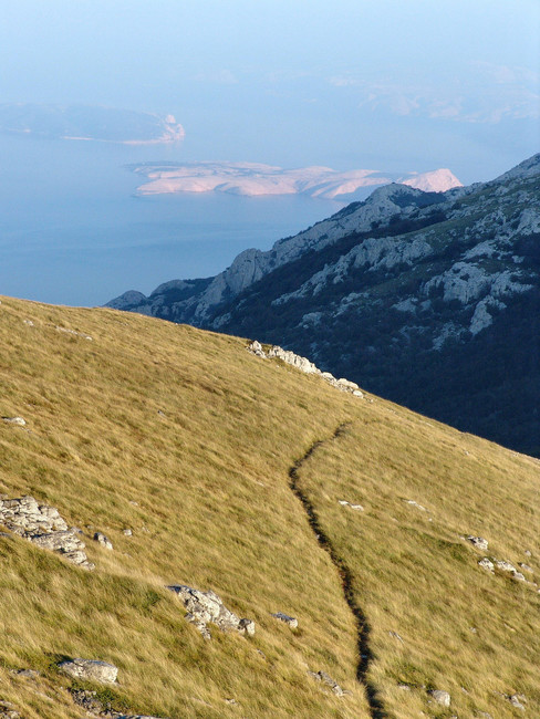
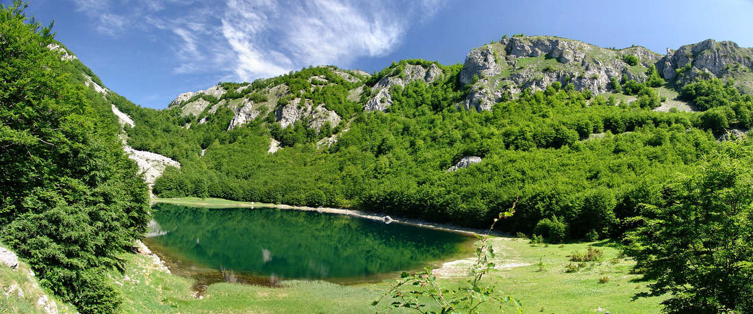
This is a well distinctive morphological area, a high limestone-dolomite karstic plateau at average height of 800 m, situated among Montenegrin coastline, Bojana / Bune river, Scutari/Skadarsko lake, Zeta river valley, Nikšić field (Nikšićko polje), Duga gorge (and tectonic depression, too) and Gacko-Bileća-Trebinje road in Eastern Herzegovina. Inside this Area, rising from the same high karstic plateau, sometimes called Old Montenegro (Stara Crna Gora) three mountain groups could be recognized: Montenegrin Maritime Range (Group I-07), Garač Group (Group I-08) and Vojnik group (I-09). Whole area is deeply influenced by karstic processes, waterless, difficult to walk over, difficult to live in.
This is a well distinctive morphological area, a high limestone-dolomite karstic plateau at average height of 800 m, situated among Montenegrin coastline, Bojana / Bune river, Scutari/Skadarsko lake, Zeta river valley, Nikšić field (Nikšićko polje), Duga gorge (and tectonic depression, too) and Gacko-Bileća-Trebinje road in Eastern Herzegovina. Inside this Area, rising from the same high karstic plateau, sometimes called Old Montenegro (Stara Crna Gora) three mountain groups could be recognized: Montenegrin Maritime Range (Group I-07), Garač Group (Group I-08) and Vojnik group (I-09). Whole area is deeply influenced by karstic processes, waterless, difficult to walk over, difficult to live in.
| Group A-07. Mountains of Maritime Montenegro Countries: Montenegro, Bosnia and Herzegovina, Croatia |
|
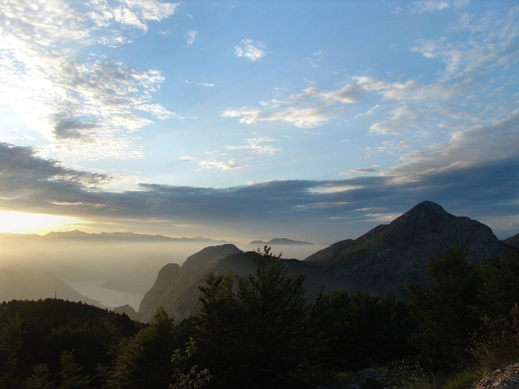
This is a mountain chain that consists of more high coastal mountains and summits as well as a Orjen massif, most of them rising from the high karstic plateau of Old Montenegro in the hinterland and falling very steeply into the Adriatic sea on the opposite side. The summit of Orjen mountain (1,849 m) is the highest one in the whole Maritime Belt. Because of theirs height and closeness to the Adriatic sea this mountain range has one of the largest European precipitation averages.
|
|
Boka kotorska bay seen from slopes of Lovćen mountain
| Group A-08. High karst plateau of Montenegro Country: Montenegro |
|
It is a trapezoid-shape karstic plateau from which more smaller mountain sub-ranges rise, the highest of them being Garač mt. at 1,436 m. While mountains of the Montenegrin Coastal Range rise from the western edge of this plateau, its NE side falls deeply into Zeta river valley in Central Montenegro. To the south the area is bordered by Scutari lake (Skadarsko jezero) and to the north, the approximate line that separates it from Montenegro´s Rudine region group is Nikšić-Trebinje road.
|
|
| Group A-09. Mountains of Montenegro´s Rudine region Countries: Montenegro, Bosnia and Herzegovina |
|
This triangular shaped region is the continuation of the same karstic plateau of Old Montenegro (the same one where High karst plateau of Montenegro group stands) from which more mountain sub-ranges rise and stretch in NW-SE direction following Gacko - Duga gorge - Nikšić fault (depression). These area is generally called Oputne Rudine.
|
|
Area overview
Actually, the division of mountains in this area could have been to Lower Eastern and Lower Western Herzegovina sub-groups (depends whether they are on western or eastern sides of Neretva river). But since Lower Western Herzegovina does not have high mountains - at least not enough distinctive to shape an important separate mountain group, I shall treat those two areas as a one group, unless there are more arguments to do it differently. In Lower Eastern Herzegovina area 2 parallel sub-ranges stretch, with highest mountains situated between towns of Stolac and Trebinje. These are Bjelašnica (Popovo polje) Range, situated between north of the right bank of Trebišnjica river and south of Stolac - Ljubinje - Ljubomir basin line and Sitnica Range situated between Stolac - Ljubinje - Ljubomir basin and and Dabar field (Dabarsko polje) - Fatnica - Bileća lines.
Actually, the division of mountains in this area could have been to Lower Eastern and Lower Western Herzegovina sub-groups (depends whether they are on western or eastern sides of Neretva river). But since Lower Western Herzegovina does not have high mountains - at least not enough distinctive to shape an important separate mountain group, I shall treat those two areas as a one group, unless there are more arguments to do it differently. In Lower Eastern Herzegovina area 2 parallel sub-ranges stretch, with highest mountains situated between towns of Stolac and Trebinje. These are Bjelašnica (Popovo polje) Range, situated between north of the right bank of Trebišnjica river and south of Stolac - Ljubinje - Ljubomir basin line and Sitnica Range situated between Stolac - Ljubinje - Ljubomir basin and and Dabar field (Dabarsko polje) - Fatnica - Bileća lines.
Area Overview
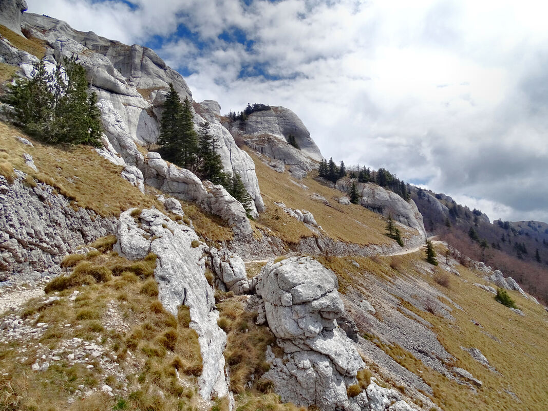
NW part of Central Dinaric Belt is characterized by high karstic plateau-like mountains as well as large karstic plateaus from which mountains ranges and summits rise. The groups in this area are determined by three major faults stretching in NW-SE direction. These are Western Fault: city of Rijeka - Reka river valley - Pivka river valley - Unec river - town of Vrhnika; Central fault: river Kupa source area - Čabranka river - Loška dolina (valley) - Cerkniško lake, and Eastern Fault: Kočevje basin - Ribnica basin - Turjak - city of Ljubljana. West of the Western Fault is Trnovski gozd Group (Group B-01). Between Western and Central Fault is Snežnik-Risnjak Group (Group B-02), and between Central and Eastern Fault is Large Notranjska-Dolenjska Plateau (Group B-03). East of the Eastern fault are lower Dinaric areas that gradually switch to Pannonian plain. High karstic plateau continues further to the southeast of Snežnik-Risnjak group, and this is Velika kapela Group (Group B-04), with more sub-ranges rising from the plateau. All this area is characterized by continuous and very large natural forests, lots of karstic features (especially sinking creeks) and is under-populated. Two of the most convenient (where Dinarics are the narrowest) and low laying mountain passes in Dinaric Alps are in this area and they are Postojna pass (Postojnska vrata/Postojna gate, known as the Gate of the Peoples, so named according to historical presence and contemporary influences of Romanic, Slavic and German peoples in the area) and Vrata pass (in Gorski kotar, region in Croatia, on Zagreb-Rijeka corridor).
NW part of Central Dinaric Belt is characterized by high karstic plateau-like mountains as well as large karstic plateaus from which mountains ranges and summits rise. The groups in this area are determined by three major faults stretching in NW-SE direction. These are Western Fault: city of Rijeka - Reka river valley - Pivka river valley - Unec river - town of Vrhnika; Central fault: river Kupa source area - Čabranka river - Loška dolina (valley) - Cerkniško lake, and Eastern Fault: Kočevje basin - Ribnica basin - Turjak - city of Ljubljana. West of the Western Fault is Trnovski gozd Group (Group B-01). Between Western and Central Fault is Snežnik-Risnjak Group (Group B-02), and between Central and Eastern Fault is Large Notranjska-Dolenjska Plateau (Group B-03). East of the Eastern fault are lower Dinaric areas that gradually switch to Pannonian plain. High karstic plateau continues further to the southeast of Snežnik-Risnjak group, and this is Velika kapela Group (Group B-04), with more sub-ranges rising from the plateau. All this area is characterized by continuous and very large natural forests, lots of karstic features (especially sinking creeks) and is under-populated. Two of the most convenient (where Dinarics are the narrowest) and low laying mountain passes in Dinaric Alps are in this area and they are Postojna pass (Postojnska vrata/Postojna gate, known as the Gate of the Peoples, so named according to historical presence and contemporary influences of Romanic, Slavic and German peoples in the area) and Vrata pass (in Gorski kotar, region in Croatia, on Zagreb-Rijeka corridor).
| Group B-01. Trnovski gozd Group Country: Slovenia |
|
This group of high karstic plateaus is bordered with Soča/Isonzo river, Kras plateau, Vipava valley and rivers of Vipava, Pivka and Idrijca. Northern sides of this group mingle with pre-Alpine heights such is Idrijsko hribovje, that shares both Alpine and Dinaric characteristics. The average height of the highest part of this area is between 900 and 1,400 m. Although the top of those highlands does not have a spectacular summits, the whole area has mountainous character and when looking from distance they really appear as mountains with steep slopes but with flat highest areas. The area is fully karstic, covered with thick woods, waterless in summer and almost no populated.
|
|
| Group B-02. Large Notranjska-Dolenjska plateau Country: Slovenia |
|
This is a highland area, stretching in NW-SE direction, with mountains of middle height, covered with woods in higher and large pastures, fields and meadows in lower areas. Inside the Group there are three clusters of mountains: Krimsko hribovje (Krim hills) just south of Slovenian capital Ljubljana, which reaches the height of 1,107 m in Krim mt.; then the heights around Bloke plateau with Slivnica mt (1,114 m), and finally elongated mountain sub-ranges in Kočevsko-ribniško area where are the highest mountains in the Group, like Goteniški Snežnik (1,289).
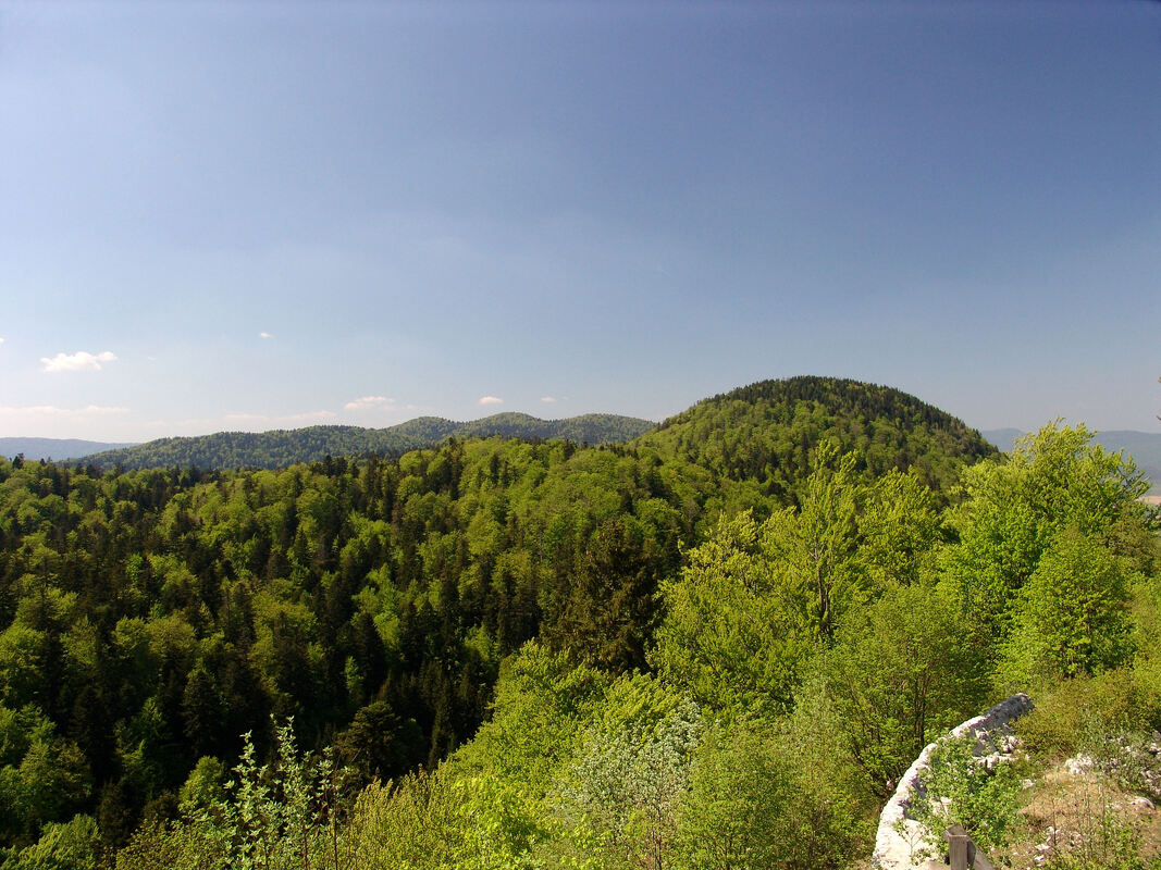
Mestni vrh peak, on Stojna mountain in Slovenia
|
Krokar Virgin Forest
Date posted: 26.3.2020. Author: Zavod za gozdove Slovenije TV Description. The film Krokar Virgin Forest presents the largest old-growth forest reserve in Slovenia - the Krokar virgin forest on Borovška gora. In 2017 it was declared as an UNESCO natural heritage site. Forest genetic research has shown that this forest is one of the extremely rare glacial refugia of European beech. Production: RTV Slovenija. The English adaptation of this film was made within the LIFE LIFEGENMON project and made possible by the Slovenian Forestry Institute, Slovenia Forest Service and the Ministry of Environment and Spatial Planning of the Republic of Slovenia. |
| Group B-03. Snežnik-Risnjak Group Countries: Slovenia; Croatia |
|
This mountain group and a huge mountain mass, is actually a high Karstic plateau with summits or mountain ranges rising from it, situated between Western and Central fault-lines and Postojna pass (in NW) and Vrata pass (in SE). The group spreads into three geographical regions: Notranjska region in Slovenia (previously this part of the plateau was called Pivka mountain, from where Snežnik massif 1,796 m and smaller Javorniki range rise), northern part of Gorski kotar region in Croatia (with Risnjak sub-group), and Rijeka (city and port) hinterland - rising above the area also called Croatian littoral or Kvarner (with three sub-ranges: Obruč, Sniježnik and elongated Littoral sub-range). The highest parts of these mountains have mountainous climate and abound in woods, they are hardly passable, sparsely populated and despite lots of precipitation (up to 4,000 mm, annually) lacking surface water in higher grounds. Only southern and southwestern slopes on the edge of the group are under sub-Mediterranean climate influences.
Forests of Snežnik mountain in Slovenia
|
| Group B-04. Velika Kapela Group Country: Croatia |
|
This mountain massif covers the southern half of Croatia´s Gorski kotar region and part of the group is also a transitional zone to Lika region, and Velebit massif, on its SE edges. It is in Kapela that Central Dinaric Belt separates in two: western part with Velebit Massif and Eastern part with Velika Kapela, Mala Kapela and Lička Plješivica (also Plješevica) mountains. Roughly, Velika Kapela is situated south of Zagreb-Rijeka corridor and north of Josipdol-Brinje-Vratnik pass-Senj corridor. Inside Velika Kapela more mountain sub-ranges stretch in NW-SE direction, separated by karstic fields, valleys and depressions, and the highest of them is the Main Kapela range, with Bjelolasica mountain (1,534 m), the highest summit of Gorski kotar region. Other mountain ranges in Kapela include Western Kapela Range, Mid-Kapela Range, and Eastern Kapela Range. Almost all the area is covered with thich woods, and only some low laying fields, valleys and some mountain tops are treeless. The whole area is very rarely populated, and waterless on the surface, despite high amounts of precipitation.
|
|
Area Overview
Lika is karstic highland region with vast fields, bordered with sharp and elongated mountain ranges of Velebit (Group B-05), Lička Plješivica (Group B-07) and Kapela.
After passing Velika Kapela group, the Central Belt of the Dinaric Alps splits into two ranges, the western one with huge Velebit mountain (massif, 1,757 m alt.), with its 145 km of length Velebit is the longest and largest mountain (massif) in the Dinaric Alps system. Eastern part of the Chain begins with some sub-ranges of Velika Kapela (velika=large), continuing into Mala Kapela (mala=small) range (Group B-06) and further to Lička Plješivica. Situated between those two ranges is large Lika basin, which consists of more karstic fields (like Lika, Krbava and Gacko fields) and at its NE edge Central Lika Range (Group B-06) stretching centrally in Lika region.
| Group B-05. Velebit massif Country: Croatia |
|
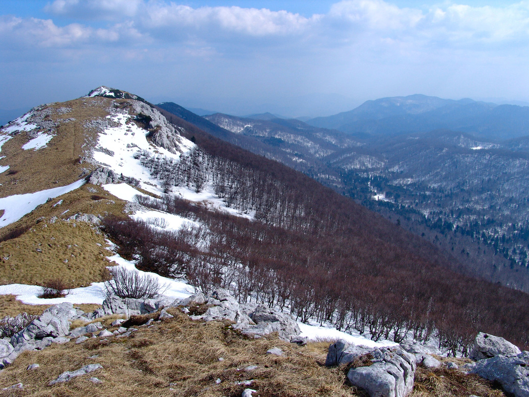
Velebit is the longest single mountain in the Dinaric Alps, stretching 145 km from Vratnik pass (above the town of Senj) to upper Zrmanja river in the SE, and between large Lika basin (actually highlands) and the Adriatic Sea. Despite the fact that Velebit is traditionally called a mountain or a massif, it i a complex structure consisting of more different parts, groups and subgroups with different characteristics. For the best reference on the mountain see the excellent Velebit page on Summit Post.
|
|
| Group B-06. Mala Kapela and Central Lika Range Country: Croatia |
|
This group is made of two main mountain ranges; Mala Kapela and Central Lika Range (Ličko sredogorje). Mala Kapela range is a continuation of more sub-ranges in Velika Kapela. Mala Kapela begins on Kapela pass (888 m alt., on Karlovac-Senj road) and stretches in NW-SE direction, until it meets Lička Plješivica in Plitvice lakes area on its SE end. Mala Kapela Range makes northern natural border of Lika highland Region in Croatia. Mala Kapela is lower but more elongated than Velika Kapela. Mala Kapela Range abounds in woods.
Central Lika Range, situated in central part of Lika region, between Lika (Ličko polje) and Krbava (Krbavsko polje) karstic fields, is a group of irregularly scattered summits and isolated mountain masses of middle height which follow the main direction - from Mala Kapela at NW, to the slopes of South-eastern Velebit near the town of Gračac, at range´s SE end. 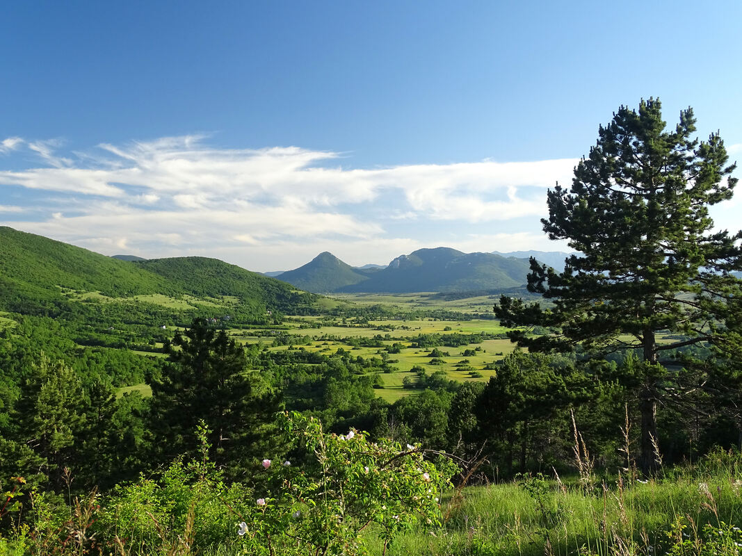
Central Lika Range in Croatia
|
|
| Group B-07. Lička Plješivica Massif Countries: Croatia, Bosnia and Herzegovina |
|
In the area of Plitvice lakes, where Mala Kapela range comes to its easternmost parts, a massif of Lička Plješivica (also, Lička Plješevica) begins. The mountain with the same name Lička Plješivica (which is made of more summits and ridges, like its highest Ozeblin at 1.649 m), stretches for the first 40 km SE of Plitvice lakes. But since more mountains and heights still continues in a row, south of Ozeblin and further to SE to the canyon of upper Zrmanja river, all those mountains are considered Plješivica in a wider sense, in this way they altogether make 100 km long Lička Plješivica massif. This massif encloses Lika basin from the East with all of its length. Northern parts of the massif are covered with woods, while central and southern parts also have vast open areas with grassy meadows and pastures.
Gola Plješivica mountain in Lička Plješivica (Plješevica) massif
|
Area Overview
West of Lika region in Croatia and across the Una river, a vast still high area of mountain masses and karstic fields (called locally Bila and polja, extends further in SE direction. The mountains are grouped in more long ranges stretching in NW-SE direction and between them more karstic fields (some of the largest in the Dinaric Alps) lay at average alt. of 700-900 m (Livanjsko, Duvanjsko, Grahovsko fields) and Kupres field (Kupreško polje) the highest of them, at 1,100 m. The area (mostly mountainous) is situated east of mid- and upper Una river flow, south of Sana river, upper Vrbas and Rama river, and west of mid-Neretva river flow. Southeastern parts of this area descend more or less gradually into Lower Western Herzegovina, or they fall steeply over Dinara massif (Group B-08) into Dalmatia region in Croatia. The dominant mountain range in the area stretch over Osječenica - Klekovača - Vitorog - Cincar mountains, diagonally, slightly curved to the south. Because of its length it has been divided into two parts, partially different in character, grouped around two "pole-mountains" - Klekovača Group (Group B-11) and Cincar group (Group B-10). SW of the main range is another smaller range named after Šator mountain (Group B-09), and more to SW on Croatian and Bosnian-Herzegovian border, one of the most known groups in Dinarics that of Dinara massif (Group B-08). NE of the main range in Western Bosnia there is somewhat lower line of summits and mountains, following all the way mid- and upper Vrbas river valley rising above the river´s left side, and named after the highest Raduša mountain (Group B-12). All area is sparsely populated, much isolated and, except Dinara and parts of Ljubuša, Cincar, Tušnica and Jelovača mountains. all other mountains in this area are very rich with woods (covered karst).
West of Lika region in Croatia and across the Una river, a vast still high area of mountain masses and karstic fields (called locally Bila and polja, extends further in SE direction. The mountains are grouped in more long ranges stretching in NW-SE direction and between them more karstic fields (some of the largest in the Dinaric Alps) lay at average alt. of 700-900 m (Livanjsko, Duvanjsko, Grahovsko fields) and Kupres field (Kupreško polje) the highest of them, at 1,100 m. The area (mostly mountainous) is situated east of mid- and upper Una river flow, south of Sana river, upper Vrbas and Rama river, and west of mid-Neretva river flow. Southeastern parts of this area descend more or less gradually into Lower Western Herzegovina, or they fall steeply over Dinara massif (Group B-08) into Dalmatia region in Croatia. The dominant mountain range in the area stretch over Osječenica - Klekovača - Vitorog - Cincar mountains, diagonally, slightly curved to the south. Because of its length it has been divided into two parts, partially different in character, grouped around two "pole-mountains" - Klekovača Group (Group B-11) and Cincar group (Group B-10). SW of the main range is another smaller range named after Šator mountain (Group B-09), and more to SW on Croatian and Bosnian-Herzegovian border, one of the most known groups in Dinarics that of Dinara massif (Group B-08). NE of the main range in Western Bosnia there is somewhat lower line of summits and mountains, following all the way mid- and upper Vrbas river valley rising above the river´s left side, and named after the highest Raduša mountain (Group B-12). All area is sparsely populated, much isolated and, except Dinara and parts of Ljubuša, Cincar, Tušnica and Jelovača mountains. all other mountains in this area are very rich with woods (covered karst).
| Group B-08. Dinara Massif Countries: Croatia, Bosnia and Herzegovina |
Dinara massif is a slightly less than 100 km elongated mountain range, situated on the border between Croatian Dalmatia region (Dalmacija) and Bosnia and Herzegovina, and it consists of four main groups/mountains: Ilica (1,654 m), Dinara (1,830 m), Troglav (1,913 m) and Kamešnica (1,855 m). The group is bordered by Grahovo field (Grahovsko polje) on NE, Livno field (Livanjsko polje) on NE and E, river Cetina valley (Peruća and Sinj fields / Perućko and Sinjsko polje) from south and Krčić and Butišnica rivers from SW and W. Although the highest in the massif is Troglav mountain, the most famous is Dinara mountain sub-group with Dinara (Sinjal) summit, the highest (1,839 m) peak in Croatia. The central and SE parts of Dinara Group (Kamešnica, Troglav and Bat) are mostly rocky, grassy with vast former pastures, while more woods can be found mostly on Ilica and Dinara mountains. Coastal influences reach SW (Dalmatian) slopes of Dinara, while NE parts are already parts of High Dinarics area with mountainous climate.
| Group B-09. Šator Range Country: Bosnia and Herzegovina |
This range is situated between Dinara massif and Klekovača-Cincar range (the main range in Western Bosnia) and above Livanjsko field (Livanjsko polje) and Grahovsko field (Grahovsko polje) from west and SW, as well as Drvarsko field (Drvarsko polje) and Glamočko field (Glamočko polje) from north and NE. The range begins east upper Una river canyon with Vučjak and Bobara mountains, and continues over Jadovnik, Šator and Staretina mountains to finish with Velika (Large) Golija mountain on its SW end. Golija is naturally connected to Cincar mountain over Koričina pass (1,113 m).
| Group B-10. Cincar Group Country: Bosnia and Herzegovina |
This mountain area is just SE part of the main Klekovača-Cincar range in Western Bosnia. Cincar (2,006 m) is the name of the highest mountain in Western Bosnia, and surrounding mountain area encompasses the mountains of the main range in Western Bosnia SE of Mlinište mountain pass (1,273 m) and North of Buško lake (Buško blato or Buško jezero located south of the town of Livno, situated between Bosnia, Dalmatia and Herzegovina regions). Along the edges of this Group run high karstic fields as are: on west Glamočko field (Glamočko polje), on SE Kupreško field (Kupreško polje) on east Duvanjsko field (Duvanjsko polje), already a transitional area to Herzegovina region, as well as Dugo polje (between Vran-planina and Čvrsnica mountains), and to the north of Cincar Group is Janj highland area. Between Mlinište pass and Cincar mountains there are still more vast mixed wooded areas. But, the more the mountains of the Group stretch to the south, the less wooded they are, and from Cincar southwards they descend in steps to Lower Herzegovina and Dalmatia. Especially the heights south and around Cincar mountain abound in grassy pastures or bare rocky terrain, which is the biggest physical difference to richly wooded Klekovača group (in NW part of the main range in Western Bosnia).
| Group B-11. Klekovača Group Country: Bosnia and Herzegovina |
Situated east of Una river, NE of Uvac river and Drvarsko field (Drvarsko polje), south and west of Sana river, and Mlinište mountain pass - making its SE edge - this is a group of elongated, karstic, wooded, middle-high mountains spreading in Dinaric NW-SE direction, and rising from Western-Bosnian highland - a sparsely populated area. The highest of the mountains in this group is Klekovača, at 1,961 m. Mountains here have distinct mountain ridges, free of woods with rocky of grassy terrain, which make them first-class view-points.
| Group B-12. Raduša Group Country: Bosnia and Herzegovina |
This is a range situated along the left side (SW) of the upper Vrbas river valley, stretching from Jajce to Prozor towns and separated by Janj highland area and Kupreško field (Kupreško polje) from the central range in Western Bosnian area (Klekovača-Cincar). Raduša is the highest mountain at 1,956 m. Mountains in the range are fully covered with thick woods (some of the largest bears in Europe were caught here around Bugojno town area). The area is still unexploited by mountaineers.
Area Overview
This is a high mountainous area situated between upper and middle Neretva river-flow, upper Rama and Sutjeska rivers, south of Željeznica and Bistrica rivers, south of Ivan pass (Ivan-sedlo, on Sarajevo-Konjic-Mostar road) and north of Eastern and Western Lower Herzegovina (north of Posušje-Mostar-Dabar field (Dabarsko polje) line). By its geomorphological characteristics High Herzegovina is just a continuation of high karst of Western Bosnia, with huge mountain masses still following Dinaric direction (except some areas around Čvrsnica mt.), and karstic fields (polja) between them, as are Nevesinjsko field (Nevesinjsko polje) or Gatačko field (Gatačko polje or Gacko polje). Like other Herzegovian mountains (both Lower and High Herzegovina) more parallel, and gradually rising (in steps, terraces) ranges and groups of mountains can be recognized.
The first in the line is a range spreading between Dabarsko field (Dabarsko polje) - Fatničko field (Fatničko polje) - Bileća town line and between Mostar - Nevesinjsko field - Gatačko field line, with Velež mt. (1,969 m) as the highest of them (GROUP B-15).
The next three groups of mountains of High Herzegovina are situated more to the north of previous Velež and Herzegovian Rudine region group, and south of the upper Neretva river. Those three ranges are: a cluster of mountains of western part of High Herzegovina, around Čvrsnica mt. (2,228 m) (GROUP B-13), then Prenj massif (2,155 m) (GROUP B-14), and a slightly lower range, running in NW-SE direction along left bank of the upper Neretva canyon, beginning with Crvanj mt. (1,921 m) and finishing with Lebršnik mt. (1,985 m) - that already enters Montenegro proper. (Group B-16)
The last line of High Herzegovian mountains is situated north of the upper and mid-Neretva valley, but this is already a transitional area, where the same mountain ranges are being shared by Herzegovina and Bosnia (in north and eastern parts) and shared by Herzegovina, Montenegro and Bosnia in the SE-most parts. This is why those mountain are put in a separate section named Central Bosnian-Herzegovian mountains.
| Group B-13. Čvrsnica group Country: Bosnia and Herzegovina |
This is a mountain area consisting of more mountains in western part of High Herzegovina, west of mid-Neretva river canyon, NW of the city of Mostar, east of Buško lake (Buško blato/ Buško jezero) and Duvanjsko field (Duvanjsko polje) and north of Mostar - Široki Brijeg - Posušje road which is roughly a transitional area with lower mountains of Western Herzegovina. NW parts of this group touch border area of Bosnia-Herzegovina and Croatia (Dalmatia region). The vastest and the highest of all mountains in the group and the highest in all of Herzegovina is Čvrsnica (2,228 m). The highest parts of the group were formed by glacial influences. Eastern parts of the group are marked by deep canyons of Neretva, Drežanka, Doljanka, Diva Grabovica rivers, up to 1,200 meters deep.
| Group B-14. Prenj massif Country: Bosnia and Herzegovina |
High mountain massif in Herzegovina region of Bosnia and Herzegovina. On the east, north and west it is limited by a wide arc of Neretva river and to the southeast are fields Bijelo Polje, Velika draga, Hansko and Bahtijevica mountain. Prenj drops steeply to the river-banks of the Neretva. The narrow ridge Barice separates Prenj into two highlands Prenj and Glogovo. Alpine climate with lots of snow. More remains of former glaciers. Because of its geology, Prenj has a lot of precipitation but little surface sources.
| Group B-15. Velež and Herzegovian Rudine region Country: Bosnia and Herzegovina |
| Group B-16. Crvanj - Lebršnik range Countries: Bosnia and Herzegovina, Montenegro |
Area Overview
This is the area with some of the highest mountains in Herzegovina and Bosnia. It encopasses the last line of High Herzegovian mountains to the north of the upper and mid-Neretva valley, but this is already a transitional area because northern and SE mountains and mountains slopes in this area already belong to Bosnia region. This is why those mountain are put in a separate section named Central Bosnian-Herzegovian mountains. The south-eastermost edges of this area already belong to Montenegro. This is area of high mountains with characteristic rounded mountain slopes at 1,000-1,500 m alt. Above them mountains and summits rise to around 2,000 meters (Bjelašnica, Vranica, Treskavica and others).
This is the area with some of the highest mountains in Herzegovina and Bosnia. It encopasses the last line of High Herzegovian mountains to the north of the upper and mid-Neretva valley, but this is already a transitional area because northern and SE mountains and mountains slopes in this area already belong to Bosnia region. This is why those mountain are put in a separate section named Central Bosnian-Herzegovian mountains. The south-eastermost edges of this area already belong to Montenegro. This is area of high mountains with characteristic rounded mountain slopes at 1,000-1,500 m alt. Above them mountains and summits rise to around 2,000 meters (Bjelašnica, Vranica, Treskavica and others).
| Group B-17. Vranica group Country: Bosnia and Herzegovina |
Geologically, this is an older geological mass grasped by a younger Dinaric built-up in later Tertiary and at the beginning of Quartenary when it got today's height and direction. Vranica is the highest mountain in Central Bosnia. And the massif of Vranica is made of many smaller mountains (small in surface area, but not in height). Although some put Vranica into group of Central Bosnian mountains belonging to NE Dinaric belt (because it very much differs from the rest of limestone mountains south and west of it), it is nevertheless the highest of all only-Bosnian mountains (other high mountains in the area are both Bosnian and Herzegovian), and morphologically it is a part of the same sub-chain with Bjelašnica, Zelengora and Maglić. The highest parts of the group are mostly vast mountain pastures, while the lower parts abound in woods.
| Group B-18. Bjelašnica group Country: Bosnia and Herzegovina |
| Group B-19. Zelengora group Country: Bosnia and Herzegovina |
It is a mountaineous area situated beetween river Bistrica (northern side), Drina and Sutjeska rivers (eastern and SE sides), Jabučnica and Neretva rivers (SE side) and Zagorje plateau (from NW). Massif consists of Zelengora mountain massif and other mountains and summits, including Lelija mt. with the highest summit in the group (2,032 m). Zelengora Group is a typical karstic-dolomite massif with sandstone layers. This is the reason why the massif abounds in water-sources, streams and small shallow lakes. Mountains in the group are covered with woods and mountain pastures.
| Group B-20. Bioč, Maglić, Volujak group Countries: Bosnia and Herzegovina, Montenegro |
This geomorpohological group is situated between regions of Herzegovina, Bosnia and Montenegro, bordered by Sutjeska, Piva and Vrbnica rivers. The highest summits are in Montenegro, while the easiest approach is from the Bosnian and Herzegovian side. Mountains of this Group encircle picturesque Trnovačko lake (Trnovačko jezero) in Montenegro. Although this mountains make a group, it never got a common name. Maglić is the most famous mountain in the Group (and also the highest summit of Bosnia-Herzegovina), although the highest summits of the Group are on another mountain, and that is Bioč (2,386 m) in Montenegro. The whole group abounds in karstic and glacial forms, with deep green valleys, narrow gorges, rocky mountain edges, high plateaus and glacially carved mountain-tops.
Area Overview
This is the Highest Dinaric Area, a high mountainous region with high vast high plateaus (Površi) and mountains (Brda) - many of them higher than 2,000 meters - rising from them. Plateaus are carved by river canyons and gorges of Tara, Piva, Lim, Morača and other rivers. Western and South western parts of the area are made of limestone and dolomite rocks, while the rest of area is less karstic (although there are still some important limestone zones here as are Durmitor, Komovi) and less barren and is built up of impenetrable slate rock formations. This area abounds in pastures, woods and surface waters.
This is the Highest Dinaric Area, a high mountainous region with high vast high plateaus (Površi) and mountains (Brda) - many of them higher than 2,000 meters - rising from them. Plateaus are carved by river canyons and gorges of Tara, Piva, Lim, Morača and other rivers. Western and South western parts of the area are made of limestone and dolomite rocks, while the rest of area is less karstic (although there are still some important limestone zones here as are Durmitor, Komovi) and less barren and is built up of impenetrable slate rock formations. This area abounds in pastures, woods and surface waters.
| Group B-21. Vojnik - Golija group Countries: Montenegro, Bosnia and Herzegovina |
| Group B-22. Prekornica group Countries: Montenegro, Bosnia and Herzegovina |
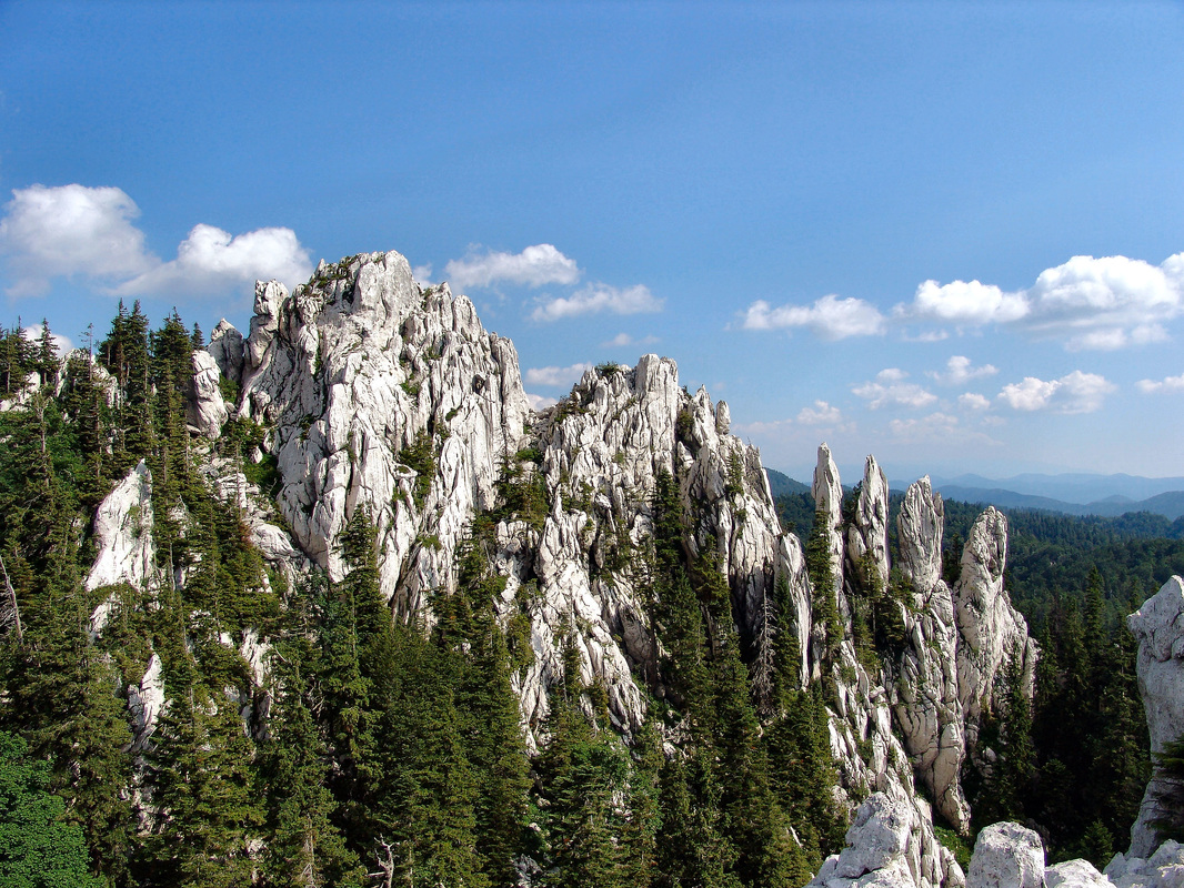
| Group B-23. Durmitor group Country: Montenegro |
| Group B-24. Sinjajevina massif Country: Montenegro |
High and elongated (around 40 km long and 15 km wide) mountain massif spreading in NW-SE direction, situated betwen Tara, Morača. Bukovica and Tušinja river canyons. The most of Sinjajevina (or Sinjavina) is a vast karstic highland also shaped by glacial forces - a natural continuation of Lakes highland (Jezerska površ) at the eastern foothills of Durmitor massif. The highlands of Sinjajevina are almost treeless, but with vast pastures. The highest peaks are situated on its SE part.
| Group B-25. Morača mountains and Maganik Country: Montenegro |
This group is located in the central part of Montenegro. It stretches to the east to Tara river canyon, near the town of Kolašin. The Gradišta ridge closes this series of peaks from the west, while Vratlo pass separates it from peaks of Sinjajevina mountain range. Moračke planine (Moračke mountains) group is surrounded from the west by Lola ridge and plateau; from the southwest by the pasture plateau Lukavica with two Žurim peaks (Mali and Veliki - Lesser and Large), and by the source and canyon of Morača river to the north and northeast. Some geographers consider some parts (the south-eastern) of Sinjajevina as a part of Moračke mountains. The mountain group is made of limestone.
| Group B-26. Ljubišnja group Country: Montenegro |
| Group B-27. Bjelasica massif Country: Montenegro |
A high mountain massif in Central Montenegro, situated between Tara (from west) and Lim river (from east) canyons. Tresnjevik mountain pass separates Bjelasica from Komovi massif to the south and Ljepesnica and Ljubovidja rivers (tributaries of Lim) make Bjelasica´s border to the north. Geologically, this massif is of volcanic structure but reshaped on the surface by glacial forces. Because of geological structure there are no sharp rocky peaks on Bjelasica but curved undulating peaks, grouped in more mountain ridges, stretching in classical NW-SE Dinaric direction. It abounds in water-sources an mountain streams. Part of Bjelasica massif is Biogradska gora National Park with primeval forests and glacial lake of the same name. Many parts of the massif are covered with woods. There are more glacial lakes on Bjelasica.
| Group B-28. Komovi group Countries: Montenegro, Albania |
| Group B-29. Visitor group Countries: Montenegro, Albania |
This is a small group by measuring its surface, but with high summits. Why such a small area makes a group? Simply, because of "negative" selection, it does not belong to Komovi group and also in the most of the cases it is not atributed to Prokletije range either (although there are more different theories, considering Visitor as part of wider Prokletije structure). The group is bordered with Plav-Gusinje glacial valley from south, Lim river valley from east and north, and Zlorijecica and Kutska rivers from west. The group has all main ridges connected together, except one spur (Lipovica) that separates in western direction across Montenegrin-Albanian border. The main mountain feature in the Group are woods, pastures, plenty water sources.
| Group B-30. Kučke mountains - Žijovo Countries: Montenegro, Albania |
It is almost untouched, pristine, remote and quiet mountainous region, situated north-east of Podgorica the capital of Montenegro, next to the Albanian border, one of not so known gems of the Montenegrin Dinarids. In fact this is a vast karstic plateau (površ) from which more groups of summits, single mountain-like summits and mountains rise. Along its western side, rivers of Morača and Mala rijeka («Small river») and road Podgorica – Lijeva Rijeka – Verusa, make the limits of the area. River Cijevna and vast river valley of Zeta make south and southwerstern borderline of Kucka krajina. To east, the area extends to the summits along Montenegrin-Albanian border and a smaller mountain ridge that enter into Albania (over Vermoshi) and finally, from the north side the first neighbor of Kucka krajina is Komovi mountain group.
| Group B-31. Prokletije/Bjeshkët e Nemuna Range Countries: Albania, Montenegro, Kosovo, Serbia |
|
The Accursed Mountains/Prokletije/Bjeshkët e Nemuna is a large, rugged, pathless and hardly passable mountain range stretching from Scutari lake (Skadarsko jezero) in NE direction over Cijevna river area, then slightly curving to the East in direction od Đeravica/Gjeravica (2,656 m) summit and local group (above Metohija basin, Kosovo area). From here, geomorpohologically Prokletije turn northwards over Bogićevica mt. (2,530 m) and Čakor mountain pass, and continue with another row of high mountains (sometimes this mountains are called Mountains of North-Eastern Montenegro) like Hajla (2,400 m), Žljeb (2,352 m), Mokra Gora (2,155 m) and Suva Planina (1,750 m) mountains, that encircle Metohija (alb. Dukagjin) basin from north and north-west and finish in the area of upper Ibar river valley.
Prokletije form the southernmost end of Dinaric mountain chain. In this area Dinaric Alps meet with Šar (read "shar", after Shar-planina/Shar Mountain) mountain system in Macedonia and Albania and Kosovo area. This tectonic crash has produced an unusual zig-zag shape of Prokletije range, and also theirs curving from dominant Dinaric NW-SE direction toward the north-eastern one (the same as of Sara mt.). This is mostly a limestone built chain (except its eastern and SE parts) with slate rock around its base. The most of the area was formed by glacial influences with karstic areas in the western parts of the Group. Although there are some serious scientific searchings that give Prokletije a status of a separate mountain chain and not a part of Dinaric chain, in most other ways this chain is still considered as the highest of all Dinaric areas, connected with Dinaric mountain chain in more ways as are geology, unbroken morphological unit and even ethnologically. |
|
The Northeastern belt consists of mountains of more complex structure. The most of them are built of Paleozoic layers and different eruptive rocks. This is the area of nonporous layers with normal above-surface water-flows, thick "network" of valleys and indented relief with more mountain groups of middle and lower height. Although the most of the mountains in this Belt consist of non-porous rocks there are still few karstic areas here. The mountains of NE Belt are richer in ores (Fe, PB, Cu, Mn, coal) than mountains in other two (karstic) belts.
On the northernmost part of this zone Dinaric Alps meet the Pannonian/Hungarian plain, and this is the area of low green mountains and hills build of later tertiary sediments. The older layers on northern edge of this zone are covered by sediments of old Pannonian sea.
The mountains of the North-Eastern Belt stretch from lower mountain ranges in Slovenia and Croatia, which are transitional zones to the European Alps. The Belt then descends to low and hilly areas of Central Croatia and east of Una river it continues in more mountain groups of Northern, Central and Eastern Bosnia (with a few higher mountains like Vlasic, Jahorina). As a morphological continuation of mountain ranges in Eastern Bosnia, more mountain ranges of Western Serbia continue east of Drina river, still following main Dinaric direction, with a slight curve to the south.
| Group C-01. Kočevski Rog group Country: Slovenia |
This group is bordered from north by Ljubljana-Zagreb highway, and from SW by a tectonic depression Kočevje-Ribnica (both are small towns). The main mountain massif in this group is forested Kočevski Rog. It is underpopulated area with half-ruined villages and more than 800 km2 of forest today, including protected primary forest (Rajhenavski gozd, Kopa and Pečke on Rog). There are may mountains paths around, but because of thick forested countryside it is easy to get lost. It is a solitude world and a heaven for animals. Other main mountains in the group are elongated, following Kočevje-Ribnica line (the fault) in SW-NE direction.
| Group C-02. Žumberak/Gorjanci group Countries: Slovenia; Croatia |
This is a low mountain massif shared by Slovenia and Croatia, 50 km long, 20 km wide, mostly karstic, with the highest summit at 1,178 m. It is situated on the edge of the Dinaric Alps, and differently from nearby Kočevski rog and the most of the Dinarics, Žumberak/Gorjanci stretches in SW-NE direction, like some other mountains of SW part of Pannonian plain (Medvednica above Zagreb). Such direction is due to tectonics, because those mountains are transitional zones, placed in collision areas of two large mountain systems (Dinaric and the main Alpine). The summits in the group are not too high, but the massif has mountainous character, forests, gentle meadows and many small canyons surrounded by steep mountain ridges.
Central and Eastern Bosnia embrace more mountain ranges and clusters in mid and lower river valleys of Vrbas, Bosna and Drina, as well as lower mountains around rivers of Sana, Vrbanja, Usora and Spreča. Southern edge of this Area is Sarajevo field - Željeznica river - Bistrica river - Drina river line.
| Group C-03. Vlašić group Country: Bosnia and Herzegovina |
| Group C-04. Jahorina massif Country: Bosnia and Herzegovina |
| Group C-05. Mountains of central Bosnia Country: Bosnia and Herzegovina |
| Group C-06. Mountains of eastern Bosnia Country: Bosnia and Herzegovina |
| Group C-07. Polimlje-Podrinje mountains Countries: Serbia, Bosnia and Herzegovina, Montenegro |
| Group C-08. Zlatar-Pešter group Countries: Serbia, Montenegro |
| Group C-09. Mountains of Stari Vlah Countries: Serbia, Bosnia and Herzegovina |
| Group C-10. Podrinje-Valjevo mountains Countriy: Serbia |
Spreading from the Pannonian plain or lowlands of the Sava River southwards, the plains gradually rise to a wide hill area that rises from 200 to 600 m above sea level, and gradually turns into a mountainous area of the Dinaric Alps.