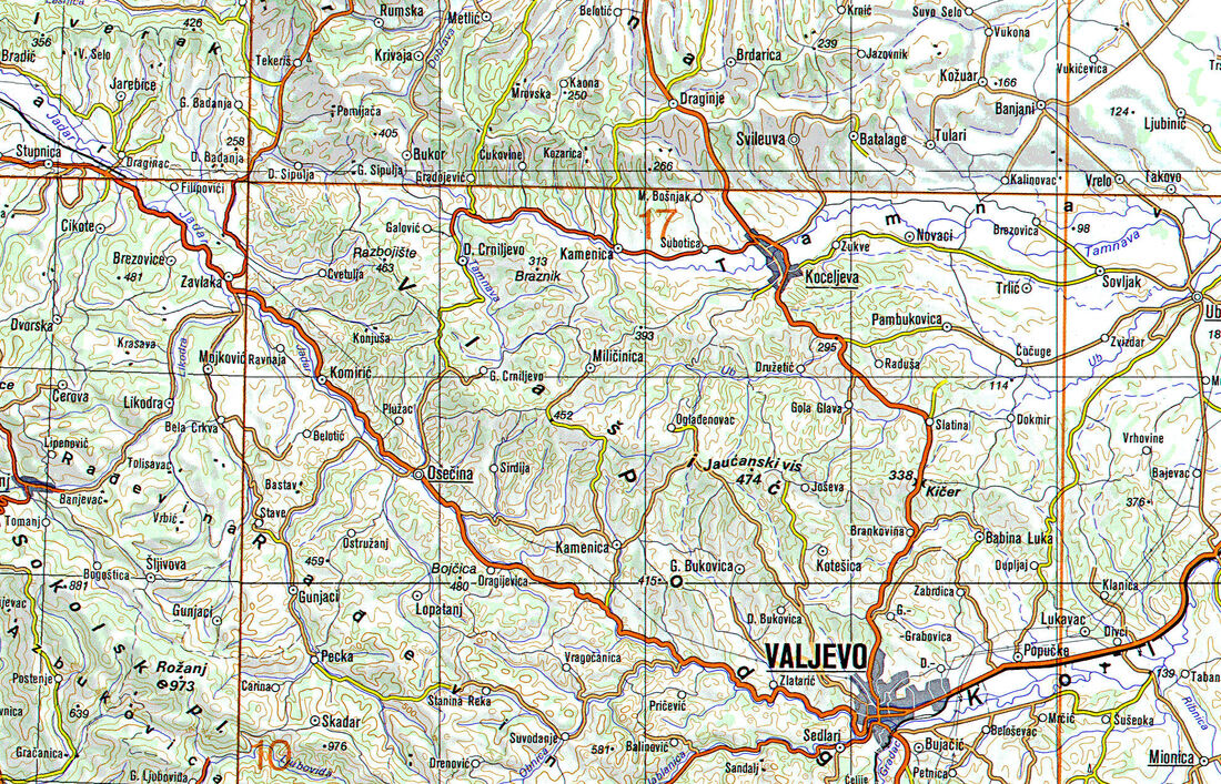
VLAŠIĆ (KOD VALJEVA) (Влашић)
Područje: Peripanonske odnosno preddinarske planine
Grupa: -
Država: Srbija
Najviši vrh: Jaućanski vis / Čot (474 m)
Koordinate najvišeg vrha: 44.37778, 19.8062
Grupa: -
Država: Srbija
Najviši vrh: Jaućanski vis / Čot (474 m)
Koordinate najvišeg vrha: 44.37778, 19.8062
O planini ...
|
UvodVlašić (ćir. Влашић) je brdo u zapadnoj Srbiji, sjeverozapadno od Valjeva između mjesta Osečina i Koceljeva, te između gornjih tijekova rijeka Velike Cernice, Tamnave i Jadra, s najvišim vrhom Jaućanski vis, odn. Čot, 474 m n.v.
Njegovim podnožjem i preko njega vode ceste Loznica--Valjevo,Šabac--Ljubovija i Šabac-Osečina. Većim dijelom je obraslo listopadnom šumom. Napomena: Različiti izvori navode različite visine i imena ovoga brda: ... Čot 474 m [1][3] ... s vrhovima od 424 do 462 metar. [2] Pristup vrhu Vlašića iz Valjeva: Radničkom ulicom do Carića, pa poludesno kroz Kotešicu do Joševe. Nakon 16 km, prije spomenika, nalazi se Jaućanski vis. ENGLISH SUMMARY: Vlašić (near Valjevo)Vlašić is a low mountain in western Serbia, northwest of the town of Valjevo, between towns of Osečina and Koceljevo, and between the upper streams of the Velika Cernica, Tamnava and Jadar rivers, with the highest peak Jaućanski vis (or Čot), 474 m of alt. The Loznica - Valjevo, Šabac - Ljubovija and Šabac - Osečina roads pass around and over the mountain. It is mostly covered with deciduous forest. |
ŠTO VRIJEDI VIDJETI I POSJETITI: Klikom na logotip Booking.com direktno pronađi smještaj u okolici Vlašića (kod Valjeva)
|
IZVORI I LITERATURA
[1] Jovan Đ. Marković: Enciklopedijski geografski leksikon Jugoslavije. Svjetlost. Sarajevo, 1990. ISBN 86-01-02651-6
[2] Wikipedija: Vlašić (brdo)
[3] Wikipedija: Vlašić (Serbia)
[2] Wikipedija: Vlašić (brdo)
[3] Wikipedija: Vlašić (Serbia)
NESTEL, Galina P., SUDAR, Milan N.,JOVANOVIĆ, Divna, KOLAR-JURKOVŠEK, Tea: Latest Permian Foraminifers from the Vlašić Mountain Area, Northwestern Serbia. Micropaleontology 55, no. 5 (2009): str. 495-513. 2009. (INFO)
- SAŽETAK: Foraminifers from the Permian-Triassic boundary interval in the upper part of the "Bituminous Limestone" Formation of the Komirić section, northwestern Serbia are described and illustrated here for the first time. Four new species of foraminifers are described: Hemigordius komiricensis n. sp., H. smiljkae n. sp., Multidiscus vlasicensis n. sp., and Eomarginulinella serbica n. sp. The genus Eomarginulinella Sosnina 1969 is considered to be a valid genus and reinstated herein. The youngest Late Permian foraminifers are found together with conodonts of the Lower Hindeodus praeparvus Zone, the next to the last of the youngest conodont zones of the Upper Permian. The assemblage of the foraminifers from the upper part of the "Bituminous Limestone" in northwestern Serbia is most similar to coeval foraminiferal assemblages from the upper Changhsingian Belolabinskaya Group of the northwestern Caucasus and from the Nagyvisnyó Limestone Formation of the Bükk Mountains in northeastern Hungary. It is less similar to coeval foraminiferal assemblages of the Carnic Alps, Central Taurides of Turkey, Transcaucasia and China.